- Area: Ross-shire
- Local Train Operators: Scotrail
- Length: 8 miles
- Points of Note: Views of several mountains and a lovely glen walk
- OS maps – Explorer 429 (1:25,000); Landranger 25 (1:50,000)
Another circular walk, owing in part to the fact that the central portion of the Skye Line is a proper railway with stations at a proper spacing. The next station to the east (Achnasheen, ever since trains stopped making unadvertised ad hoc calls at Glen Carron Halt at some unspecified date) is 12 miles away over largely trackless terrain, which slightly constrains setting out walks that other people can follow. But it’s a very pleasant circle for all that.
Take a proper map, stout footwear, a good camera and your school geography textbook with the bookmark placed against the chapter on features of glaciated landscapes.
___…___
Achnashellach station started out as one of the Skye Line’s private stations for satisfying landowners. These landowners paid a great deal of money for the railway and it was only fair that it made some efforts to serve them. Excepting Glen Carron, all these stations are now used by the general public.
Achnashellach’s operating heyday has passed – it lacks proper buildings, its once-important siding and the later crossing loop – but is still blessed with a low platform for weeding out those who are bad at mountaineering. (Ironically the abandoned platform is the newer one, and so closer to modern standards.)

Once the train has sorted itself out and cleared off in whichever direction it happens to be going, exit the station down the ramp at the Kyle (west) end and turn right over the level crossing. Follow the track up the hill to the right.
It almost immediately comes to a diamond cross-track. Double-back to the left and follow this track as it swings along the bottom of the hillside, keeping an eye out for paths off to the left.
One should eventually appear, not quite half a mile into the walk, not far from the end of the track and purporting to point in the wrong direction. Drop down towards the river until the path decides to regain its correct direction and starts working back up the valley into the mountains.
The climb up past the lump of mountain described by the map as “The Nose” is long but very beautiful.
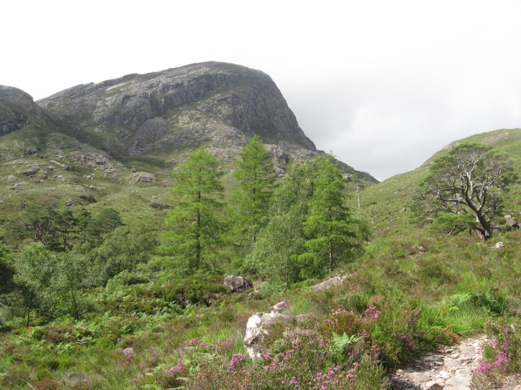
Anyway, the occasional pause to look back will reveal a steadily growing vista southwards, with Strath Carron and Loch Dughaill at the bottom.

Around the path are the various loose rocks which your geography textbook will call “erratics” and possibly even say something useful about.
Eventually the path levels out rather abruptly as it enters the River Lair’s hanging valley, some 330 metres above the Carron. Here the path divides into several walking opportunities, including two Munros, an almost-ran (Fuar Tholl is 7m too short for a Munro), the onward path over the pass ahead which eventually leads back to the main road at a point awkwardly equidistant between Strathcarron and Achnashellach stations, and the walk being done here.

This particular walk involves crossing this area by turning right as much as possible without doing any more serious climbing. The path runs roughly level past the words “Drochaid Coire Lair” on the map and then, after maybe half a mile of this walking at moderate height, begins to fall (more gently) into another valley.
The valley is trackless, and the fall reasonably steady, until it finally comes to a confluence at a waterfall and a Scottish mountain bothy. The bothy is marked on the map as a small black rectangle with a creamy filling; it is the only building for some miles, so is fairly easy to identify.

Dotted around are masses of Scots pines, busy being highly scenic.
From the bothy things become perhaps excessively civilised; there is a hard track for vehicular access to some local dams, which is followed eastwards.
The valley eventually widens for the next confluence and prepares to swing away to the north.

At the confluence there is a bridge carrying another track over the river so that the track can head away southwards. Turn right, cross the bridge and follow the track.

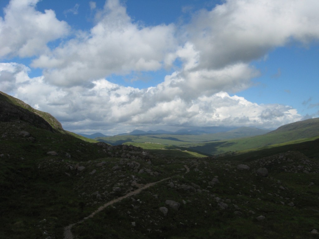
The track, after some initial deliberations, settles down to a straight southerly heading up the east side of the valley, en route to the Coulin Pass. Once again, it is worth stopping periodically to look back at the view. This stretches away northwards through the rolling green mountains until it is cut off by the more severe ridge around Spidean Coire nan Clach (977m).

The eventual pass looks quite innocent when approached from the north, but turns out to emerge high up a mountain above Strath Carron with some dramatic views of the U-shaped valley (check geography textbook). Far below and away are Loch Dughaill and Loch Carron, which in turn leads into Loch Kishorn.

Speaking of the geography textbook, if you grew up in the South of England you probably never believed in this kind of scenery when it was shown as little artists drawings of exaggerated U-shaped valleys with hanging valleys at the tops of the sides.
The forestry track will now lead gently back down the hillside, over the course of a couple of miles, to the diamond cross-tracks that opened the walk. Admire the views and small waterfalls on the way. Go straight on at the cross-tracks and come out at the level crossing by the station.

The Kyle line service of four daily trains is not one of the nation’s great examples of turn-up-and-go train operating, so have a book on hand for the dawdle pending the train home.
The rustic, peaceful and quite isolated station was the centre of a rather amusing accident in 1892 when a train turned up from Inverness late one night formed with a loco, eight wagons (with no continuous brake controlled from the loco), three coaches (with the usual nine passengers) and a guard’s van (usually referred to alternatively as a brake van, but in this case the brake was defective). Once the train had stopped arrangements were made to uncouple the loco from the whole train prior to detaching the front two wagons from the remainder and hauling them into the dead-end siding with a tow rope. The uncoupling involved the loco squeezing the buffers between itself and the first wagon of the train to loosen the coupling chain enough to unhook it from the wagon. As it was detached from the loco the train rolled backwards very slightly, found it was on a gently descending slope into Glen Carron and escaped down the hill, leaving the loco and crew to watch as the darkness swallowed it up. Some brakes had been applied, but the working brakes were a bit useless and the useful brakes were broken.
After an appropriate tiff the crew got on the loco and chased after the unlit runaway train, which they encountered near the bottom of the valley after it had run partway up the next hill, stopped and run back down again. The wagons bore the brunt of the immediate impact; the passengers were merely thrown about a bit; the loco crew and stationmaster shared the brunt of the blame in the official report with the Board of the Highland Railway, who were not supposed to be condoning or justifying the operation of passenger trains not fitted with continuous brakes.
The station is properly a halt now, being merely a request stop; proper lighting is provided to aid efforts to by the driver identify late-night travellers.
