In view of this blog having taken a serious turn lately, and bearing in mind that it is likely to be serious for a bit, for post 100 here is something a little lighter…
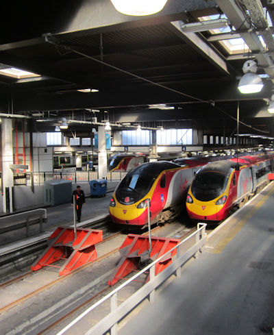
 Inverness station, North Highland platform. A 4-car 158 sits in platform 5 – 158705 is nearest, looking grubby, with 158717 behind quietly gleaming. Between them they form the 17:54 Sundays-excepted “for Wick ‘n’ Thurso and Kyle o’ Lochalsh. Passengers for Wick ‘n’ Thurso should travel in the front two coaches and in the rear two coaches for Kyle o’ Lochalsh. Passengers travelling to Beauly this evening will need to alight from the front door of the second coach.” The Beauly part of the announcement, now augmented by Conon Bridge, almost adds to the interest of this train into the far distant wilds of Northern Scotland; both stations have platforms about 50ft long. The 17:54 used to divide at Dingwall, with the Wick portion striking on into the North and the Kyle portion then trundling Westwards. No more – Wick now has its own departure a full half-hour later and the 17:54 is for Kyle only.
Growing up brought me family holidays to various destinations and also a certain interest in distant parts of UK geography. A Midlands kid by birth, I have always been reasonably well-up on what the world around places like Peterborough, Kettering and Leicester looks like (rolling with fields) but a bit vague on places in the extremities, like Cornwall and Scotland. I had a vision of Scotland as a land of mountains coated in snow and pine trees.
Cornwall was resolved by going to university there. It provided a good opportunity to explore the place and I grabbed it, trundling around the rail network, walking patches of the coastal path and exploring rural lanes. Periodically I potter back over the Tamar again to look in on some old haunt.
Scotland had to wait until I left home, when an idle few minutes looking at National Rail Enquiries saw me make the not exactly staggering discovery that the Far North of Scotland is accessible from the Great Western Corridor in a day’s rail travel. A long day, but a day all the same.
The first bit of advice I received on this was to not take this as an excuse to go all the way up there one day and come back the next day. I took it. This was to be a proper holiday, for which I bought the relevant maps and studied things to do while pushing North of Edinburgh for the first time. It was not any proper holiday though. It was the cherry-popper – the first holiday to an unfamiliar area that I organised myself for my enjoyment.
 The twinkling lights of Edinburgh from the Salisbury Crags during my first visit to the city. It was the farthest North I’d ever been at the time (my previous record was Carlisle). The excitement and interest was in some regards tamed by being there with friends for the Edinburgh Festival Fringe. Aside from the Fringe providing structure to proceedings, there is that little mite extra excitement for going somewhere miles off one’s beaten track for the first time with no company to anchor it to previous experience.
 Druimuachdar Pass, highest point on the UK rail network. A key landmark on the run up to Inverness from Perth. Later the train clambers over Slochd summit and then coasts downhill into Inverness; sea level is reached at the beginning of Inverness station throat. My journey over here had the extra frisson that every yard the train pushed northwards was another yard further north on my personal map of the world.
Passing on from Druimuachdar, the train took me up to Inverness and then, after a 50-minute change via a shopping centre takeaway, handed me on to another for the journey wending across Scotland, down Strath Carron to Kyle of Lochalsh. My ultimate destination was a small village called Caol Acain, or Kyleakin – the gateway to Skye.
Music, maestro…
Speed, bonnie boat, like a bird on the wing,
Onward! the sailors cry;
Carry the lad that’s born to be King
Over the sea to Skye.
Loud the winds howl, loud the waves roar,
Thunderclaps rend the air;
Baffled, our foes stand by the shore,
Follow they will not dare.
Speed, bonnie boat, like a bird on the wing,
Onward! the sailors cry;
Carry the lad that’s born to be King
Over the sea to Skye.
Though the waves leap, soft shall ye sleep,
Ocean’s a royal bed.
Rocked in the deep, Flora will keep
Watch by your weary head.
Speed, bonnie boat, like a bird on the wing,
Onward! the sailors cry;
Carry the lad that’s born to be King
Over the sea to Skye.
Many’s the lad fought on that day,
Well the Claymore could wield,
When the night came, silently lay
Dead in Culloden’s field.
Speed, bonnie boat, like a bird on the wing,
Onward! the sailors cry;
Carry the lad that’s born to be King
Over the sea to Skye.
Burned are their homes, exile and death
Scatter the loyal men;
Yet ere the sword cool in the sheath
Charlie will come again.
Speed, bonnie boat, like a bird on the wing,
Onward! the sailors cry;
Carry the lad that’s born to be King
Over the sea…
To…
Skye…
 Unfortunately I did the holiday in October. Or perhaps not unfortunately, for as well as the excitement from having no company to anchor me to previous experiences there was also the interest from not having seen any of the last two hours of train journey to anchor me to the world I had come from. What little evidence of progress there was through the dark skies of Ross-shire in our rather lost little “158” came from the automated announcements as we passed the pools of light that marked intermediate stations only known to me from books and the slightly historical Driver’s Eye View Skye Train. “This is Achnasheen,” said the computerised Scottish lady, as we halted somewhere on a bit of moorland. “This train is for Kyle of Lochalsh. The next stop is Achnashellach.”
(But unlike the most recent time I did the run, at least we remembered to stop at Achnashellach. It is slightly embarrassing, even when representing the only train for forty miles, to have to back up into the 18-inch-high platform set beneath a mountainous escarpment in Glen Carron. Particularly in daylight.)
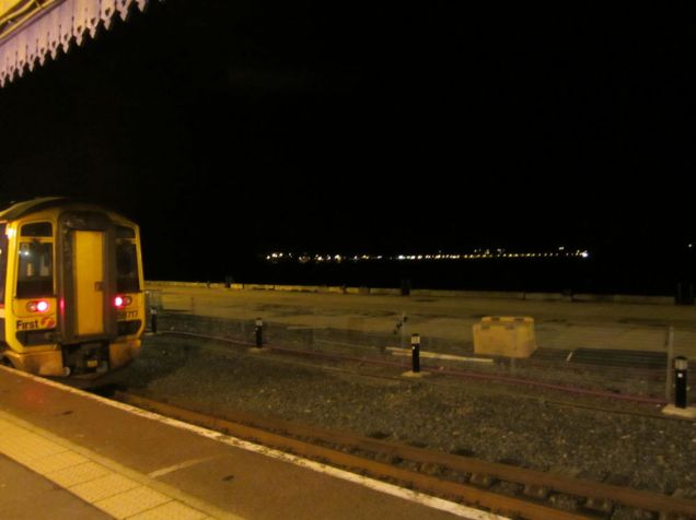 This was therefore my first view of Kyleakin, when 158717 had brought the 17:54 safely to its remote destination. For the Kyleakin-bound traveller, the Skye Mainline train wends down the side of Loch Carron, cuts through a promontory and pushes out into Loch Alsh before announcing it’s going no further and you’re on your own. The crew then add emphasis to this by turning off the engines and locking the “158” up for the night. It is a pleasant 45-minute walk from Kyle of Lochalsh station to Kyleakin, which adds a further certain frisson of adventure when done in the dark. A pavement follows the road all the way over to Skye.
 Journey’s end not yet reached, but Kyle of Lochalsh is the last place on the A87 on the British mainland. The road out of Kyle was built with the Skye Bridge in 1996, hence its relatively modern appearance. Until the bridge came, traffic was routed down the side of Kyle station to the ferry loading point for the crossing of the Kyle Akin, at the head of Loch Alsh, to Skye’s heather and mountains.
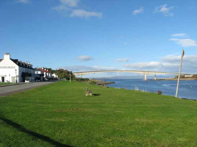 Daylight brings sight of Kyleakin properly after a chance to get enough sleep to appreciate it. I arrived in Morar in the same sort of conditions 18 months later; it’s my preferred way to begin a holiday when the last leg is fairly simple and the journey long. Between the main road and the kyle is a pleasing village green, overlooked by hostels, hotels and private housing. Beyond is the vast form of the arching Skye Bridge, carrying the A87 from mainland to island; occasionally views are expressed that Skye barely constitutes an island when you can drive onto it in a few seconds. For me, stepping onto the bridge was the first time I had been off the British mainland in three years; hardly an emotional moment, but a notable one all the same. The little island to the right, once an isolated scrap of rock carrying a small cottage only accessible by water, is now the support for a trunk road. It is notable for something; I forget precisely what.
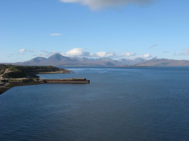 To the North are the Red Cuillins, which make up the backbone of this part of Skye, and the insignificant low-lying islet of Pabay which measures perhaps one square mile. Between us and the glacier-ridden form of Beinn na Caillich is the township of Broadford, out of view behind a small promontory to the left – a ribbon development along the A87 as it heads deeper into Skye. Broadford is also the junction for the A851 to Armadale. While the ferry at Kyleakin has gone, the ferry at Armadale still runs across the water to Mallaig. Mallaig has direct road and rail access to Fort William and Glasgow, but the voyage across the Sound of Sleat is much longer than that across Loch Alsh. The air is very clear in this part of Scotland and to those used to the more polluted atmosphere of Southern England distances can be very deceptive. The mountain is about 10 miles away and rises in a sheer sort of way to 732 metres. Curiously, despite it being usual in this area for things that are several miles away to appear to be a nice short walk, the submarine HMS Astute got everything the other way about in misjudging distances and collided with Skye in this general vicinity shortly after launching in 2010. It conjured up pleasing images of masses of foreign spies realising they could get a look at a world-leading submarine in a comparatively accessible location and crowding on the pierhead at Kyle with binoculars. Kyle of Lochalsh was one proposed base for the UK nuclear deterrent, but what with one thing and another it went to Faslane instead.
 Kyleakin’s main road runs down a promontory into the loch, to the right of this picture. Behind this promontory is the mouth of a stream called the An t-Ob; the landmass to the left being called the South Obbe. A bridge crosses the An t-Ob (with impressive water flows beneath at low tide) and the lane leads on down the north edge of the South Obbe past another dozen houses. Looking upstream provides a lovely little dell, with the foothills of one of Skye’s mountains in the background – this foothill being the Cnoc a Mhadaidh-ruaidh.
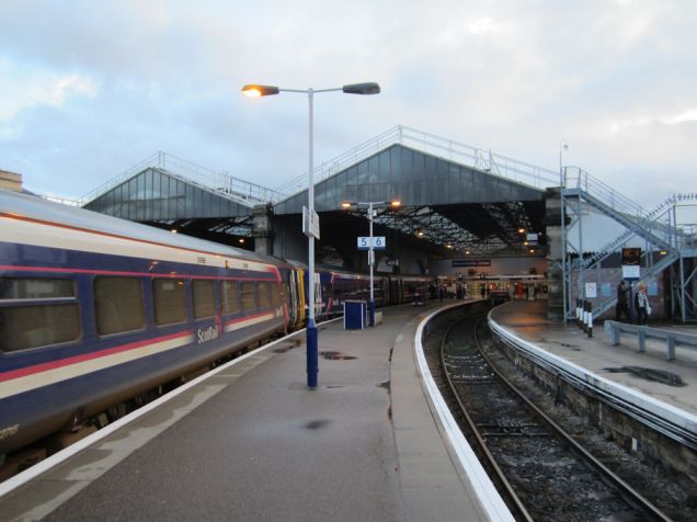
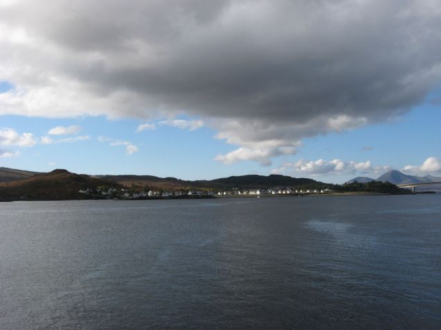
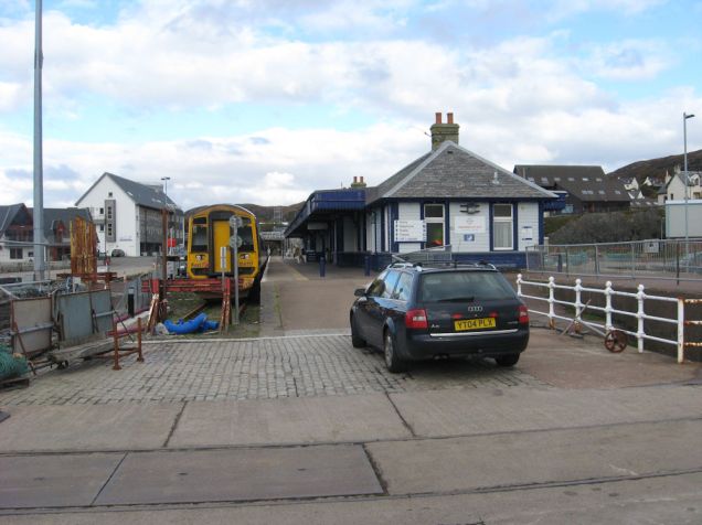 Daylight, and we return to the mainland to see Kyle of Lochalsh station from its unattractive end, looking north. Trips to Kyle while doing self-catering holidays in Kyleakin are fairly essential, as Kyle has the area’s Co-op (though Kyleakin has a corner shop that can fulfil some needs). At 5.72 degrees west and pointing almost due south, the station indicates towards a point just the slightest smidgen of a degree further west than Land’s End. The summer Sunday timetable gives Kyle two round trips, one starting at Kyle and the other at Inverness. The winter timetable simply withdraws the Kyle trip and the unit that arrived at Kyle on Saturday night remains there until Monday morning. The Inverness trip uses platform 2, to the right, with the peculiar consequence that the station appears at its busiest on Sundays out of season. 158717 is doing the honours on this particular Sunday morning after ferrying me in the night before. The station has an exposed feel in the middle of the loch, though is extensively sheltered by Skye. It is still interesting to ponder what the 158s make of this treatment, particularly in the depths of winter. The end of the running line represents one of the farthest extremes of the British rail network; being on the end of a pier in a loch gives it a finality lacked by land-based places like Mallaig, Penzance, Lowestoft (farthest east) or indeed Wick and Thurso. Stranraer is probably the nearest comparator. Kyle’s large station building is now a cafe, museum and ticket office. Beyond it a ramp leads up to the road bridge that carries the A87 over the platform. This ramp acts as access route, station car park, drop off area and anything else that it happens to be needed for. In the foreground is the remains of one of the pier’s sidings, accessed by wagon turntables, which allowed goods to be transshipped to onward ferries. As well as Skye, the station was also once the port for Stornaway on Lewis. This was regrettably transferred to Ullapool in the 1970s – shortening the crossing, but as a 1940s plan to build a branch from the Kyle line at Garve to Ullapool never came to fruition rail access is a trifle more difficult.
 From the same point as above, looking the other way across the water. The headland of South Obbe squats to the left; Beinn na Caillich is off to the right behind the Skye Bridge. In between is the white strip of properties that make up Kyleakin, with the wooded headland hiding Kyle House and the landing point for the bridge.
 Another overall view of Kyleakin, this time from Caisteal Maol to the east of the village. The main road curves across the green and then sweeps around the front of the houses on the promontory, finishing on the pier to the right. Parked on it was a minibus calling for something about Libya. The bridge again dominates the background scene. It was built as a private finance initiative and tolled accordingly (£5 single for a bridge maybe half a mile long), with the result that one of the first acts of the Scottish Government on getting transport devolved was to buy out the concession holder. This cost a similar price to building the bridge in the first price. Running a new concrete bridge not being a very extravagant affair, most of the £33million taken in tolls during the intervening 9 years presumably went in someone’s profits. The station museum has up a list of excuses for refusing to pay the tolls, but my favourite story is that agricultural traffic went over free so someone established a nice sideline leasing sheep for people to carry over the bridge in their cars. By the time I reached the area all that remained of the toll booths was a widening in the road, but the tourist board and all accommodation providers remained very keen to emphasise that the tolls had gone.
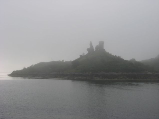 Moyle Castle/ Caistell Maol rises out of a summer mist on Loch Alsh, seem from the ferry slipway. The castle was never more than a single tower guarding the loch, more for the purposes of extorting passers-by than defending against enemies. A combination of dereliction and the local weather means that not a great deal is left, but it makes a suitably moody starring feature of this sort of picture.
 A rather cheerier autumnal day, with the birds flying around the ruined castle and its heather-covered hill reflected in the bright blue waters of Loch Alsh beneath a clear sky. Note the tide marks. This is a particularly restful scene and the photo is one of which I am particularly fond.
 The loch stretches inland from the castle, which frames it nicely. The little lighthouse visible on the jutting rock centre left is on the island of Eileanan Dubha. A few miles up the loch a narrow passage off to the right called Kyle Rhea separates Skye from the mainland by a few hundred yards; it is spanned by a seasonal ferry near the hamlet of Kylerhea and leads on out into the Sound of Sleat past Mallaig and towards the Small Isles. At the head of Loch Alsh, just hidden by the headland of Avernish, is the restored castle at Eilean Donan. I have a rather nice painting of this on my wall (picked up at Tintern a year or so ago) but have to quietly cough when visitors ask if I’ve ever actually been. Kyleakin is a good base for exploring, but on my visits I’ve tended to be more satisfied with having got there without trundling eight miles up the loch along the A87. One can argue at much length whether Eilean Donan or Caistell Maol is the more authentic structure; this one is in ruins, while Eilean Donan looks so good because it was rebuilt in the 20th century after being blown up in the 18th.
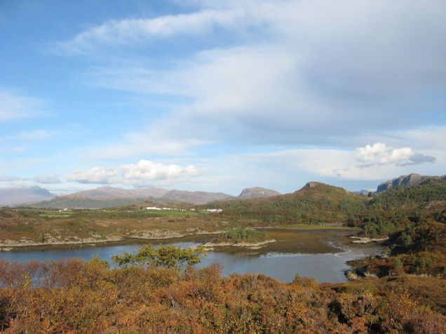 One does not have to get very far from Kyleakin to do quite a good deal of exploring. The varied array of views and multitudes of snug, hidden locations mean that clawing repeatedly over a few square miles is not actually that repetitive. This is a bay south-west of Plockton, between there and Duirinish. Plockton is the other notable centre of population on the Kyle line apart from Kyle of Lochalsh and about half a dozen miles up the coast at the entrance to Loch Carron. Scottish land law does not acknowledge public footpaths, instead declaring the entire country to be (within general good reason) open access. This allows for a great deal of tramping through heather before deciding that perhaps the concept is not necessarily as all-freeing as it might be. Still, it allows for a certain variety of views and a part of this one graces the cover of a notebook that I wander around with for jotting down thoughts and inspirations – or failing that email addresses for people I might want to get hold of again, rules for card games, locations of handy takeaways for the list and other such things.
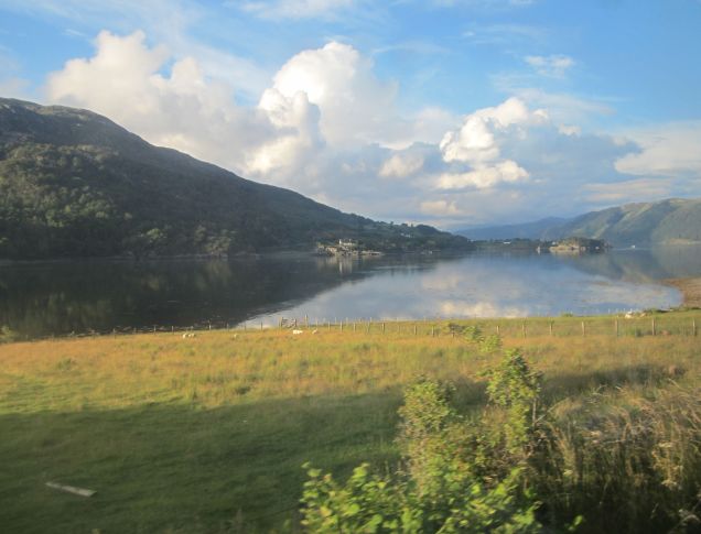 When it’s not late at night in October (for example, when it’s mid-evening in mid-summer), the Kyle line is generally agreed to be worth the trip to Kyleakin in itself. Personally I advise against doing out-and-back runs of any of the rural Scottish lines in a day with intention of viewing the scenery, as it will start to wear after a while. Much better to spend a few days enjoying being at the end of the line, but the journey by train from Inverness is the sort of journey which makes it worth leaving the car at home and skipping the bus options.
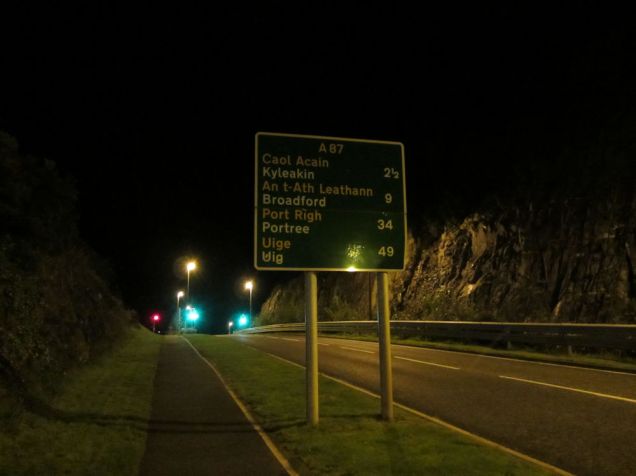
 The train also serves such wonderful places as Strome Ferry. Strome Ferry was largely created by the railway as the original terminus, the Kyle extension being stupendously expensive for reasons most readily explained by travelling on it. Strome Ferry thus got to be the centre of 19th-century campaigns to preserve the Sabbath from desecration by railway companies that wanted to take the Saturday fishing catch to London on a Sunday. Otherwise the attractions of Strome Ferry are largely summarised by this (faintly iconic) road sign.
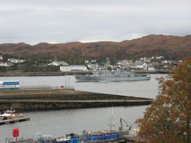 The Royal Navy on manoeuvres past Kyleakin, seen from South Obbe. The minibus on the pier is sat at left. This particular piece of Navy kit managed to navigate Caol Acain without wrecking itself on anything. Beyond is Kyle of Lochalsh, with the large form of the Lochalsh hotel above the ship’s bows.
 Kyleakin also has a twin-peaked mountain of its own, the higher bit of which is called Sgurr na Coinnich. It is a pathless mountain which rises squarely from sea level behind Kyleakin to a height of 739m in about 2 miles (3km – an average gradient of about 1 in 4). For those who can be bothered to clamber over the heather and patches of bog all the way to the top, the views are no doubt rather good. For those (like me) who get bored three-quarters of the way up, there are still some handsome views of the Red Cuillins, the rest of Skye stretching northwards, the Applecross Peninsular (pictured), the bridge, Kyle of Lochalsh town and station and, tucked against the south face of the Kyle of Loch Alsh, the village of Kyleakin itself. Clouds streak close overhead and helicopters chatter past below on their way down the loch. Looking down at the right time will provide very distant views of the little Class 158s bringing a few more people across from Inverness to the area – from shopping, for holidays, for walks or for a cup of tea at the Lochalsh hotel before heading east again.
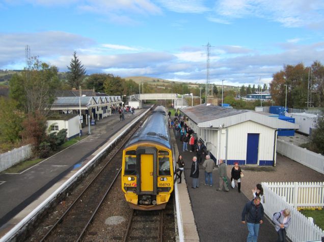 Rather than strike straight back South, I took three nights in Thurso after doing Skye. This meant changing at Dingwall for a Far North train. 158713 is seen with the lunchtime train from Kyle, back in civilisation and preparing to do the Inverness metro run through Muir of Ord and Beauly to the Highland capital. A few moments later 158714 slid in alongside with the mid-afternoon Inverness – Kyle service. The junction is at the north end of the station beyond the bridge. Kyle to Thurso on this set of connections takes 5¾ hours, of which ½-hour is spent at Dingwall and the rest chattering along in 158s at up to 75mph. (The 75 is on the Far North route, which has been upgraded to broadly mainline status, albeit single track. The Kyle line has jointed track and a limit of 45. The investment in keeping the Far North Mainline fast is worth it, despite the minimal population; it is a sobering thought that Inverness is less than two-thirds of the way between Edinburgh and Thurso.)
 The Far North is not Skye, but it is really worth a visit. One of the least densely-populated regions in Europe, there is nowhere else quite like it in Britain. The main road from Forsinard (which consists of a railway station and a hotel) is seen heading for the next notable centre of population at Helmsdale, a trifle under 50 miles away to the south. The OS map of the area features about the same mileage of road as railway.
After this was over I spent a day and a bit heading from Thurso to Falmouth by rail. That’s another story. So we will finish with this instead:
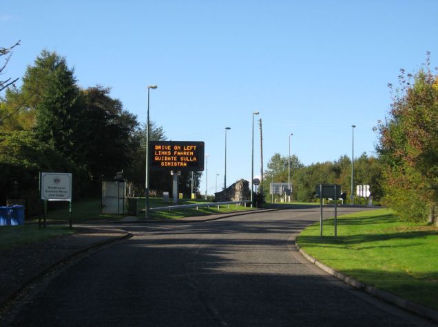 Even fairly casual users of the British road network will be familiar with the “wayside pulpits” which preach valuable information like “don’t drink and drive” in neat LED block capitals and present warnings of queues ahead to the three-mile-tailback behind the latest motorway pile-up. There are also wayside pulpits around the A87, which lacking major traffic events to report upon are obliged to consider other points of note. Drivers coming out of the Port of Kyleakin onto the A87 are therefore confronted with this sign. As the Port of Kyleakin consists of the derelict slipway for a ferry remarked on above, exactly what traffic is expected to emanate from Kyleakin that is unfamiliar with basic British road usage is unclear. If this is all the pulpit has to say one wonders what the business case for it was. Anyway, this is what Skye wayside pulpits preach on.
(Almost as good as a pair of road signs I met in Morar, 30 miles or a day’s rail travelling away, which kindly reminded me that on zebra crossings pedestrians have priority.)
It is on this cheery note that I will move on, pondering when I will get round to tripping up to the North Highlands again. Or perhaps not quite on that note. I came across this poem in a magazine shortly after my first return from the Highlands and while I have always gone North from Kings Cross (excepting my Morar trip) it seemed to capture something.
At Euston
Stranger with the pile of luggage proudly labelled for Portree
How I wish this night of August I were you and you were me!
Think of all that lies before you when the train goes sliding forth,
And the lines athwart the sunset lead you swiftly to the North.
Think of breakfast at Kingussie, think of high Drumochter Pass,
Think of Highland breezes singing through the bracken and the grass.
Scabious blue and yellow daisy, tender fern beside the train,
Rowdy Tummel, falling, brawling, seen and lost, and glimpsed again.
You will pass my golden roadway of the days of long ago.
Will you realise the magic of the names I used to know,
Clachnaharry, Achnashellach, Achnasheen and Duirinish?
Every moor alive with coveys, every pool aboil with fish.
Every well-remembered vista, more exciting mile by mile,
Till the wheeling gulls screaming round the engine at the Kyle.
Think of cloud on Bheinn na Cailleach, jagged Cuchullins soaring high,
Scent of peat, and all the glamour of the misty Isle of Skye.
Rods and guncase in the carriage, wise retriever in the van;
Go; and good luck travel with you! (Wish I’d half your luck, my man!)
A. M. Harbord