It’s 105 years since the Western Front guns stopped and the Western Front ceasefire on the First World War began.
And afterwards, people remembered.
Some of the declarations on behalf of the dead have seemed dubiously warlike:
In Flanders fields the poppies blow Between the crosses, row on row, That mark our place; and in the sky The larks, still bravely singing, fly Scarce heard amid the guns below. We are the Dead. Short days ago We lived, felt dawn, saw sunset glow, Loved and were loved, and now we lie, In Flanders fields. Take up our quarrel with the foe: To you from failing hands we throw The torch; be yours to hold it high. If ye break faith with us who die We shall not sleep, though poppies grow In Flanders fields.
Read in the wrong mood, it seems terribly like Mr McCrae wouldn’t mind terribly if the UK marked Remembrance Day by carpet-nuking the Germans.
At the other extreme, it represents the “Never Again” version. Yet the German rematch 21 years later shows that there are people who are unresponsive to suggestions that they should live in peace and harmony with their neighbours, and it is tricky to shut such people up without beating them to death with a rifle butt.
And yet…
The silent cut-outs scattered around the country suggest a better use of Remembrance of the war dead. War may be beneficial, or it may be lousy, or it may be unjustified, or it may depose tyrants. Those all depend on individual wars, and indeed individual perspectives on those wars (the Falklands Conflict, for example, remains the subject of conflicting interpretations for personal, patriotic and political reasons).
But the cut out figures, the Unknown Warrior in his tomb and the lists of names on memorials around the country silently speak a truth that some seem to promptly forget upon rising to power – that war has a most terrible human cost.
I’m not going to stand looking at Reading’s cut-out and proclaim the greatness of our part in the Great War, but I am going to remember that some people died in wars, and some people still die in wars, and it is very sad, and it would be better if the people who run these things could find a better way forward where not so many people sadly die and are remembered (especially not so many people sadly die and are remembered in Mr McCrae’s faintly vindictive tones).
We have a few heritage railways around the country having various degrees of financial difficulty at the moment, which prompts thoughts about what can be done with them…
Origins
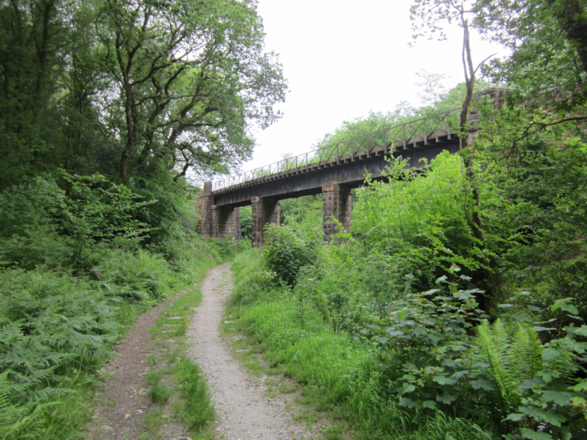
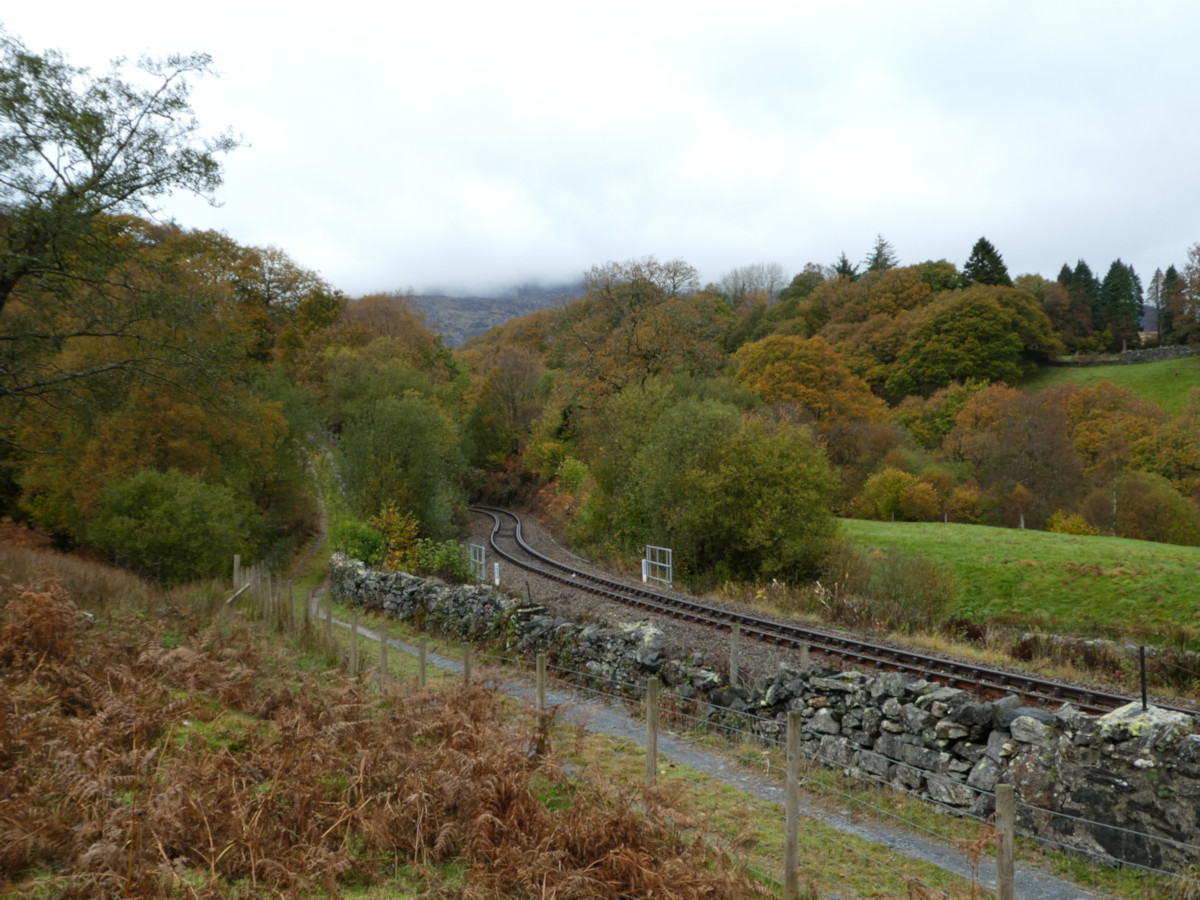
Disused railways go back a surprisingly long way. In the UK they are associated with Government disinvestment in the 1960s, which left 10,000 miles of spare trackbeds running around the country. But this one became a dead railway after the line was diverted over the viaduct in the background somewhat earlier than that:
Ever since, there has been a question of what to do with it.
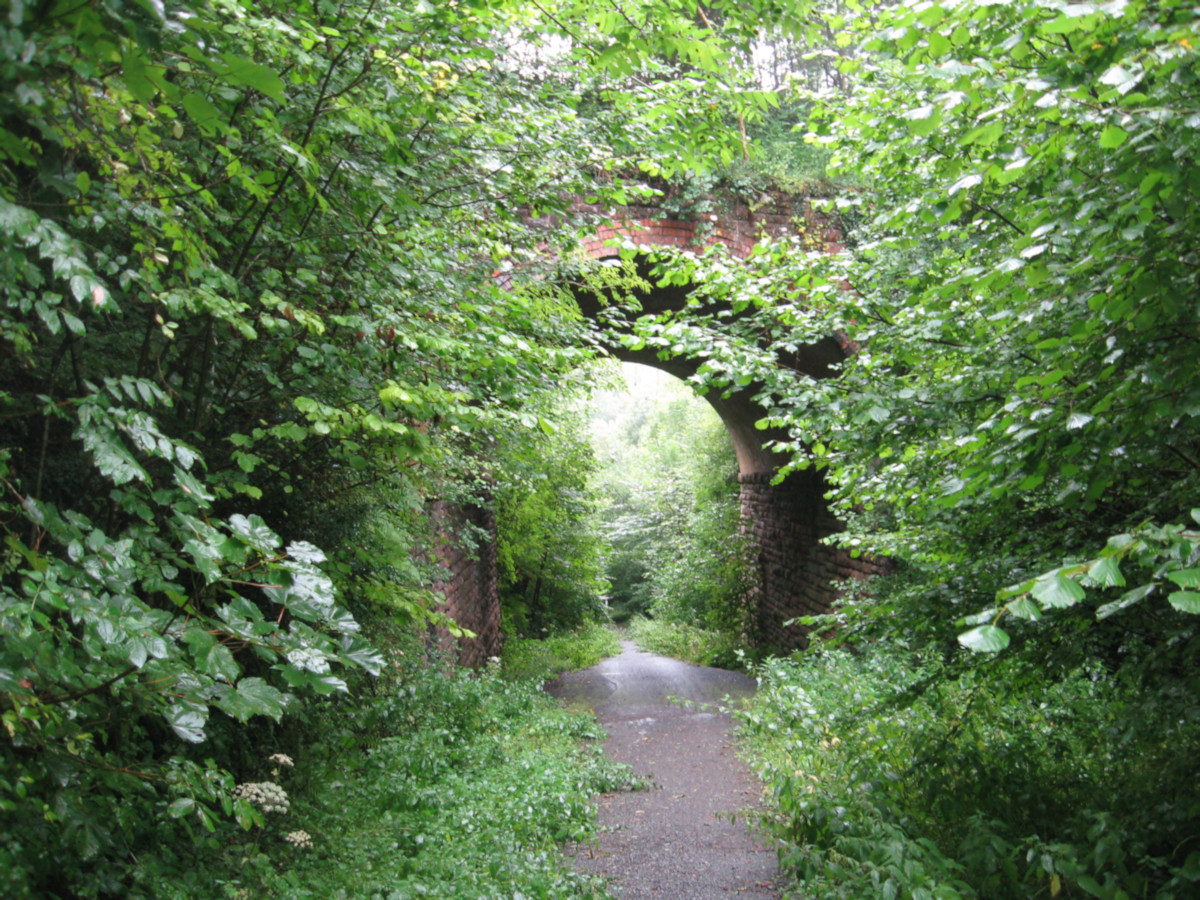
Nothing
This simple solution can be pursued with most pre-1900 abandonments, and more than a few more recent closures. Trackbeds consisting of a scratch across rolling fields, through woods and along hillsides can be left to return to the landscape. Nobody will notice very much.
It has the bonus of being very cheap to do. If any earthworks do exist on the scratch and they do happen to collapse then there won’t be complaints because nothing was being done with them anyway.
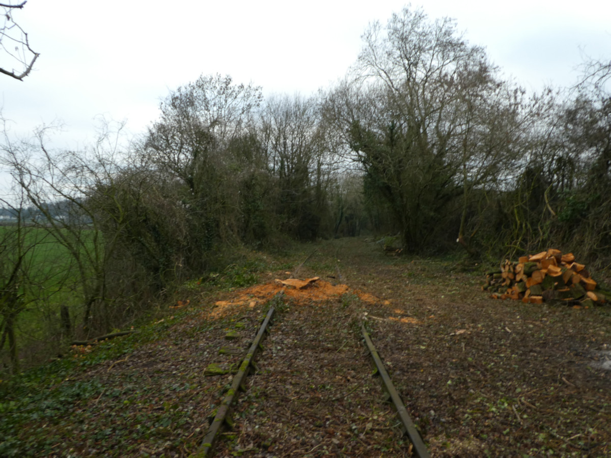
A disused railway, near Coleford in the Forest of Dean.The same policy can be followed with roads too, which simplifies matters where the dead road and dead railway cross each other.
Where a railway has heavy infrastructure then a pure “Nothing” policy can result in expensive things like tunnels caving in, so in these cases it is preferable to put in some more effort.
Landscape out of existence
This heading considers the option pursued where after landscaping nothing is immediately done with the land, except selling it back to a farmer or planting some trees on it. It is quite popular in some ex-industrial areas where there is a desire to tidy up remnants of buildings, platforms, embankments and cuttings as part of a programme of making an area both safer and less derelict.
People do notice this at first, and industrial archaeologists disapprove, but it can turn some grubby loading area into a pleasant bit of parkland.
Marsh Sidings, Parkend, as was – the trackbed for the headshunt remains as the trough in the ground ahead, and the rest has been smoothed out into a patch of grass by a road.
National Highways has been reviving this option lately to get rid of some old railway bridges that aren’t being used at the moment, with the short(ish)-term maintenance savings being kept in-hand to bring them back into use if someone needs them later. Considering that they are mostly fairly small railway bridges being maintained with money that could otherwise go towards useful things like repairing potholes this exercise is surprisingly unpopular. Some of them have obvious uses but there is little prospect of these obvious uses happening in the next ten years.
A grander scale could yet be taken on structures like Pensford Viaduct – someone has built a house across the end of it, so it is now sitting around waiting to fall down. (From a point of view of worthwhile use of taxpayer’s money, either knock down the housing estate and put the railway back or accept the housing estate and knock down the viaduct.) Occasionally such viaducts are still removed from the landscape.
You don’t have to use these things for railways of course.
Bypasses
There have been a few examples of this down the years. It is hit-and-miss. Long wandering branchlines that miss all the centres of population that they serve are best, but have the small problem that they didn’t really follow any major traffic flows or go past any major centres of population that need bypassing.
If next week the Welsh Government decided to close the line from Llandudno to Blaenau Ffestiniog then the section past Dolwyddelan would make an excellent bypass. But it’s debatable whether Dolwyddelan really needs a bypass, given traffic levels, the size of the village and the money poured into upgrading the A470 through the village already. Also it’s not a very straight railway and it’s only single track, so a decent bypass would need a lot of money pouring into straightening it out and widening existing infrastructure.
Go on – fit a 60mph road on this…
The town en route which does need a bypass is Llanwrst…
… but the railway passes under Llanwrst in a single-track tunnel so is a fat lot of use for that.
The council in Caernarvon has tried using the railway tunnel under part of the town for one of three expressways to ease the town’s purported traffic problems (never really noticed them myself) but it doesn’t add anything worthwhile to connectivity and isn’t heavily used. It makes a nice way for cyclists to avoid road junctions around the old town though.
Would be good for pedestrians too if they hadn’t taken out a traffic order banning pedestrians…
Which leads into:
Cyclepaths
Many, many miles of disused railway have been converted into cyclepaths.
The problem with this is that walking and cycling is perceived as being of relatively little economic relevance – people can always walk and cycle elsewhere – so there isn’t a great deal of money knocking around. No matter – this is easily presented as a community exercise as the skills required for some elements of construction and most elements of maintenance are quite limited.
This is very fine and pleasant so lots of cyclepaths opened up relatively easily on lots of railways, and they do quite well until it turns out that those solid Victorian railway structures need heavy maintenance. This is occasionally planned, sometimes imposed by the Council and once in a while imposed by the weather. After that happens they can be closed for some while, the cyclepath ends up being a bit useless and the community has to rustle up a million quid or so for repairs. While a bridge for a cyclepath can be to a lighter standard than a bridge that carries trains or cars, and can be left for longer than a bridge that carries trains or cars, it is still necessary for such a bridge to be capable of not falling over.
Broadly, nowadays a cyclepath on a disused railway will hit a lot of the same capital costs as a railway on a disused railway excluding laying new track.
On looking at some railways it can be tempting to say that actually the cyclepath has more costs because it has to take away the old track, but actually this track was pretty rotten so would have to have been taken away – eventually – anyway. The railway would also have had to properly remove the tree – it may be noted that the cyclepath people decided it looked pretty.
Heritage Railways
So there is an argument for reopening disused railways as heritage railways, not out of some wannabe enthusiasm but simply because that way there is some money coming in to pay for the bridge repairs.
Look – fare-paying passengers!
Sadly the fare-paying passengers only cover the movement costs of the trains (and that only if the railway is particularly busy), so major infrastructure costs still need funding separately.
In the early years this was aided on most heritage railways by British Railways having pulled out after some spot repairs and before major works became necessary to maintain infrastructure for 70mph running. Reducing speeds to 25mph, combined with running less regularly, could get a few more years out of the infrastructure.
If a railway can’t argue that it generates several million quid of economic value for an area every year then it has to pay for these bridges itself. This can result in a steady stream of appeals to raise another £18,000 to repoint and waterproof another bridge. (In terms of railway infrastructure this is dirt cheap, though is almost twice as much as I have spent on home repairs in one shot – and actually that was aided by a 10-year financing package.)
You can get the railway to share with a cyclepath or vice-versa, which helps to spread some of the bills around.
Housing
This works well in built-up areas, and to an extent in rural ones where more housing happens to be useful.
It has the small problem that railways are linear things so the housing estates have to be linear too. This can be OK, but only to a point.
Sometimes in urban areas it can feel rather a waste to destroy a transport corridor even if it is of no use for a railway, too narrow for a road and too expensive for a cyclepath.
Spot the former railway formation. Cutting infilled, former station and viaduct approach covered in houses, viaduct demolished, buddleia in foreground on other end of viaduct.
National Rail
This is the gold-plated use for disused railway infrastructure. Restore the railway properly, replace dead bridges, reline the tunnels, reinstate stations. Depending on what was left over this can end up looking like a new railway.
This railway station on a re-opened line has some hallmarks of an old one that’s always been there (mainly that brick platform wall).
This one is a new build on a new site (albeit on an old formation).
Exactly how useful this is does depend a bit on the railway, but it should always be an option to reasonably consider with a reasonably intact formation that goes somewhere and which needs money spending.
The Point
Railways are expensive things with expensive structures (duh).
Inevitably these expenses are rising as it becomes more of a habit to do jobs properly with experts (instead of ad-hoc volunteer exercises) to create long-term solutions, while the structures involved get older and generate more problems.
Where a railway has existed Society effectively has a choice between doing something useful with it or getting rid as much as possible. The in-between option of keeping it because it looks pretty ultimately costs a fortune and the “looks pretty” is very much a matter of taste.
Where a railway is facing financial difficulties it needs to be accepted that should it fail outright there will be costs dumped on a layer of Government, either to maintain now-useless structures or to demolish them. This should be taken into consideration for deciding whether to bail out such enterprises on a one-off basis (e.g. if a railway closes due in part to bridge repair bills and the Council will have to spend £400k keeping those bridges up, either for decorative retention or for conversion into a cyclepath, then it would be reasonable for the Council to offer to spend that £400k on those bridges on the railway’s behalf and thereby keep the benefits of the railway).
Similarly if a Council (or National Highways) is having to consider major spending on an old railway structure then some effort should be made to find a use for it, not just make it look nice.
Ingleton Viaduct demonstrates another challenge in this sort of regard – it does sit nicely in the landscape, but it would be a bit of an intrusion on privacy if a footpath was put over it and it doesn’t really go anywhere, even if both ends could be made accessible.
By contrast this tunnel is on an existing cycleway and does go somewhere, especially now the north portal has been exhumed, so why it remains sealed up at public expense when it could provide some kind of transport value is one of those intriguing questions.
In the long term there are no cheap ways forward if railway structures are to be retained in a safe condition. Where they are to be kept the surrounding trackbed should be kept intact to maximise opportunities for earning their keep.
Not just railways of course – the old solution for this canal was infilling and bypasses and new roads, but now what’s left is a public amenity as a canal. Note expensive flood defenses and concrete lining.
The main joy of a new high-speed railway being built is of course the anticipation of being able to get to places more quickly (I should find that journeys to North Yorkshire are about two hours quicker than current) but there is a side interest in watching progress.
For those living under a stone or outside the UK, High Speed 2 is the new railway from London that goes about halfway to Scotland and then joins the existing route. The rationale is fairly simple:
Too many people fly between London and Scotland (about half the market).
These people won’t go by train because a) it is too slow, b) it is too overcrowded, c) they believe it is too expensive (is £32.80 to go from London to Glasgow expensive?) and d) in some cases they don’t like trains (people are funny like that).
The half of the market that goes by train requires rather fast trains that cost a lot to run and keep running over slower trains which stop at places like Watford, Milton Keynes, Nuneaton or Stafford.
The West Coast Mainline already has a second set of tracks for non-fast trains but these are full of slower freights and even slower passenger trains which stop at places like Hemel Hempstead, Berkhamstead and Tring, so are unsuitable for trains running non-stop at 110mph from Watford to Milton Keynes.
There is a further set of tracks between London and Watford which are full of trains serving places like South Kenton and Kensal.
Therefore to provide more capacity to Scotland and more capacity for people who want to live in Milton Keynes, Nuneaton and other such places these rather fast trains need moving to their own set of tracks, so that they don’t keep catching up with other trains and more other trains can be run.
If you make it a very fast route then you can solve the “slow” problem and if you make it even a moderately straight route you can stop using tilting trains on it (which deals with the claustrophobia and nausea induced by the current fleet).
By contrast, if you just build a new pair of tracks alongside the existing tracks you have to do exciting things like knocking down Watford’s existing station, knocking down most of central Leighton Buzzard and knocking down Berkhamstead Castle, owing to the existing railway going through lots of places.
As it goes through all these places on sharp curves you commit to building a new fleet of UK-specific tilting trains to replace the existing Pendolinos when they turn 30 in 2033 and start falling to bits, which is the most expensive possible order for new trains and just ends up with a load of trains which half the passengers don’t like because they’re claustrophobic.
Most of the costs involved in building a new very fast railway are created by the words “building”, “new” and “railway” with the “very fast” being a marginal addition. Building is expensive with its demands for yellow bulldozers, supplies of concrete and quantities of land; new stuff ends up knocking over people’s houses, pretty trees and long-standing hills regardless of where you put it, and people in the area get upset about this; railways are infrastructure-heavy and regulation-heavy. After which the fact that the railway is particularly straight is really just a footnote, and arguably saves money because there’s less of it.
The problem is that to justify an alternative very fast route it is necessary to run lots of trains on it, so it can only be justified south of Liverpool and Manchester where there are lots of existing rather fast trains that might benefit from being made very fast. North of Liverpool and Manchester there’s various opportunities for accelerating trains heading to Preston/ Blackpool/ the Lake District by sticking them on a high-speed line for a bit (which would also get them off the existing infrastructure through central Manchester) but once in the Lake District a new mainline might carry five trains per hour each way at a push (2 trains London to Glasgow/ Edinburgh, one train each from Birmingham/ Manchester/ Liverpool to Glasgow/ Edinburgh) – not really enough to be worth building one.
This results in building a busy very fast line between London, Birmingham and Manchester, which causes a great deal of confusion because people mistake it for a very fast line from London to Birmingham rather than a very fast line from London to halfway to Scotland which carries the fast Birmingham trains to improve the business case.
Having removed all the rather fast trains from the existing lines between London, Birmingham, Manchester, Liverpool and Leeds these routes can be filled up with slower trains that do interesting things like allow passengers to travel from Nuneaton to Manchester more frequently than once an hour, or do Coventry to Manchester in significantly less than 2 hours.
Also places like Rugby will no longer be dominated by the sound of eleven trains per hour shooting through without stopping (they’re an impressive sight, and worth looking up on Youtube, but their removal to somewhere over Kenilworth way will not in itself have a direct effect on the quality of service to Rugby).
There is a popular argument that you could just upgrade the existing West Coast Mainline. What this looks like is being demonstrated for six weeks between the start of March and mid-April, when Carstairs station will be closed for major remodelling and the service between Carlisle and Glasgow will therefore be rather limited. (Not as limited as it could be. Avanti will be running a shuttle service between Carlisle and Glasgow over the alternative route via Dumfries. When I last got tied up in such a block under Virgin Trains a supply of buses was laid on, augmented by the booked service via Dumfries of 2-car Class 156 non-air-conditioned 75mph diesel trains calling at all stations from Carlisle to the outskirts of Glasgow. Very pretty route. Some things improve.) An effective upgrade of the West Coast Mainline involves a rolling programme of such blockades. Simpler to build new.
So we are building new. And the point of this post is to see how it’s going.
Euston
The west side of the traditional London terminus of the West Coast Mainline, to be the southern end of HS2, is becoming a hole in the ground. Tunnel to Old Oak Common’s not started yet. Officially it is expected to be opened a little after the HS2 core, with Old Oak being the initial terminus for a selection of trains. An interesting feature of current predictions for HS2 progress is that if Old Oak is a little late and Euston goes very well they may yet open together.
Old Oak Common
The interchange with the Great Western Mainline and the Elizabeth Line, and not a long way from the London Overground hub at Willesden Junction or the Central Line station at North Acton. Someone should really provide some proper covered connections. This is currently a very large hole in the ground which looks something like this:
As things stand it will allow HS2 passengers from Birmingham to connect with GWR trains to Bristol, which is not immediately the most useful of exercises as Birmingham to Bristol can be done more directly with Cross Country via Cheltenham. It also allows HS2 passengers to change onto the Elizabeth Line, which is invaluable (as the Elizabeth Line goes through the heart of London and out into Essex and Kent, which isn’t possible from Euston, as well as connecting to Heathrow Airport and the Thames Valley). What is currently a nuisance journey from Maidenhead to Manchester (train to London Paddington (30mins) – change for the Circle Line – train to Euston Square (about 10mins) – walk to Euston – train to Manchester (2hrs) – tram to wherever in Manchester is the actual destination – say 4hrs) will become a rather simple business (train to Old Oak (20mins) – change for HS2 – train to Manchester (1hr) – tram to wherever in Manchester is the actual destination – say 2hrs). Links to the Central Line and London Overground would make it a good way to disperse GWR Intercity passengers around London more quickly.
At the north end of Old Oak Common is a large box to contain all the pointwork to allow trains to depart from any platform to go north (or arrive in any platform from the north) – this is also underway. A sense of progress can be gained by comparing this HS2 video from the start of November 2022…
…with this video from “Mr Bottom” (who is a helpful recorder of HS2 progress around London) from yesterday:
Leaving London
Two sets of tunnels need digging to get to the edge of London at West Ruislip – one from Old Oak to a halfway point at Greenford, and the other from West Ruislip to Greenford. The Old Oak end is yet to start (the box is making good progress but not that good). Caroline and Sushila are currently working in from the West Ruislip end. One of them cut through an old borehole and pumped a load of slurry up it, which provides some indication on the ground as to where they’ve got to, but will subsequently have stuck a tunnel lining segment across the bottom of the hole.
At the north end of the tunnels, just north of West Ruislip station at the top end of the Central Line, the line surfaces for the first time after leaving Euston. Here a cutting is being dug out, a concrete box is being inserted into it to run the railway through, and in due course the hill will be rebuilt on top. This helps to reduce the noise around West Ruislip.
It is interesting that there is no skimping on cutting quality for the temporary cuttings that will eventually be tunnels. Where traditional railway builders would be tempted to say “It’ll only be a cutting for three weeks” and go with sheer walls (well, that’s what they built on the permanent cuttings too), HS2 is carefully sloping back the cutting walls to minimise risk of landslips while they build the tunnel walls and roofs. In most places this increases land take, and time, and cost.
Here at Copthall it has no impact on land take because the plan was a cutting but someone decided to put a tunnel in it to maintain the local scenic beauties. This is relevant if you were wondering why the HS2 cost keeps increasing. (It also generates another load of embodied carbon in concrete and steel rebar to pay off. This environmental protection thing is challenging.)
The Colne Valley
Some artificial lakes need to be crossed here, so a viaduct is being built. It’s a concrete viaduct, but some effort has been made in designing it so it looks quite good as concrete viaducts go. (Would look better if someone had cast a fake stone block effect on the surface, which in a century or so would have the same pleasant weathered stone effect as Calstock Viaduct in south-west England, but you can’t have everything.)
The first video here shows the lake crossing, with its low splayed piers, and the second shows the viaduct marching along the north shore of the lakes at tree-top height. The lake crossing is currently accompanied by a service road to deliver concrete to the piers – this will go when the viaduct is finished.
The second video picks up a lot of traffic noise, which is rather interesting to compare with this video of TGVs at line speed.
After this the line vanishes into the Chiltern Tunnels. There’s not much new to see on the surface, so the Chiltern Society don’t buzz over as much. The formation between the viaduct and the tunnel looks more or less complete and gives a good sense of the profile of the line, aided by the finished overbridge in the intermediate cutting – though the concrete factory will go and the whole lot be grassed over.
HS2 is pleased with progress underground.
From the middle of the tunnel to Kenilworth was covered a few months ago by this rather nice view from an aeroplane, but more progress has been made since.
The Chiltern Society have some pictures of the tunnel ventilation shafts, but there is not much to see at them (unlike traditional railway tunnels, which were bored outwards from the bottom of the ventilation shafts, the Chiltern Tunnels are being bored from one end to the other). The north portal makes an interesting sight though. “Karl Vaughan” on Youtube is also good for keeping up with work northwards from where the line surfaces at Great Missenden:
The viaduct over a side valley south of Wendover (Wendover Dean) does not yet seem to have got much further than some foundations, though a farm which was in the way has been cleared and HS2 appears to intend on replacing it with wildflower meadows. The Small Dean Viaduct, where the line crosses the main valley to avoid demolishing Wendover, has not got much further than chopping down the trees which were in the way. Some houses which were in the way of the Wendover cut-and-cover tunnel have been demolished and work seems to be starting on doing things in that area (thus far HS2 has nothing much to say about the Wendover Tunnel either). And thus we leave the Chilterns.
The railway drops onto the Buckinghamshire plains and shoots past the western flank of Aylesbury, north end of Chiltern Railways’s stopping service from London Marylebone, with piles of earth around the line to help block out the sound of passing trains from the houses. People who bought houses on the western side of Aylesbury can rest assured that they won’t lose their edge-of-town position. However, such views of open fields as they had will be replaced with woodland. (Most of them appeared to look out on trees anyway.)
For a spot of amusement, in the video above compare the railway formation with the new southern bypass, which is also shredding some fields and hedgerows next to a housing estate but doesn’t seem to bother anyone.
The video below features the foundations of the Thame Valley Viaduct – a long low structure which is intended to be partly hidden by trees to avoid the challenge of making a long low viaduct visually attractive.
The next section of line involves a lengthy diversion of the A41 to simplify bridge construction. At the moment the road crosses the rail alignment at a very flat angle. So instead it will run alongside the railway to meet the Blackgrove road at a roundabout and cross the line at a right angle. This will also get rid of the rather disagreeable staggered crossroads seen in the video at 1:24, and it saves the railway builders the cost of the second road bridge.
From here HS2 takes up the route of the closed Great Central Railway, adopting the only bit that’s of real use.
South of Aylesbury the old GCR consists of two tracks which are full of Chiltern Railways and Metropolitan Line services (and which feed into a tiny London terminal with annoyingly short platforms).
North of Brackley, the GCR veers off to Rugby (not big enough or far enough out to be worth serving with a high-speed line), Leicester (probably also not worth serving with a high-speed line as its already only an hour from London, and via Brackley is hardly the shortest way of getting there), Nottingham (has built on its bits so a new formation would be needed round the city) and various other places which aren’t Birmingham. Eventually it took a twisty 65mph route from Sheffield to Manchester; the Manchester approach is clogged with more stopping services, and it’s a meandering way of getting to Scotland.
Along the way HS2 is crossed by East/West Rail; the main bridge girders were installed yesterday (Twitter link). It would be nice to have a station here but it’s never quite clear what one would achieve, except possibly by acting as a giant Parkway in an area with atrocious road access.
“The Boy” on Youtube is rather good for keeping track of the section from Brackley to Leamington, where several bits of formation seem to be approaching completion (there is also one rather distracting short bit which has been completed, to show what the rest will look like). The huge piles of spoil will be tidied up and covered in trees to contain any noise that the trains make, producing a pleasant linear nature reserve. For now they look rather untidy. Remember that they dominate the video because they are what the video is focusing on, and a drone trotting along here with its camera pointed off to the right would see miles of monoculture farmland, interspersed by a few hedgerows and patches of trees.
A large chunk of this section is going to be the Greatworth cut-and-cover tunnel, so on this particular section a lot of the mud will be put back where it came from and replanted as monoculture farmland once the tunnel segments are in place. Though one would expect an exception to the recreation of the old landscape to be made at 4:10 where the former Towcester to Banbury line crosses the formation.
Banbury Lane, at the start of this next video, will be spanned by the Lower Thorpe Viaduct. Just beyond the north end of the viaduct the particularly thick hedgerow cutting across the landscape at right-angles – with a bridge off to the right – is the former line from Woodford Halse on the Great Central mainline to Banbury on the Great Western’s Birmingham route.
Further up, the especially boggy bit of landscape at Welsh Road is the River Cherwell, which flows down from Woodford Halse through Banbury to meet the Thames at Oxford. It will be crossed by the 515m Edgcote Viaduct, for which no significant work appears to have started yet beyond some tree removal and very select earth movements. The next section of formation is very untouched until the A361 Ilfracombe to Kilsbury trunk road is met at Chipping Warden. Here the old airfield has been opened up to allow the construction of another cut-and-cover tunnel.
There were some difficulties with the concrete quality for the “green tunnel”, seen properly at the start of this next bit, which have now been sorted. The cutting – and its tunnel – are progressing well. In due course the tunnel should disappear back beneath the earth again and the land above can be re-planted.
Just north of the Chipping Warden cutting-cum-tunnel HS2 crosses the remains of the Stratford-upon-Avon & Midland Junction Railway on its way from Stratford through Fenny Compton to Towcester and so eventually to Bedford. There were a lot of pleasant meandering lines in this neck of the woods – none of them traditionally very busy as there is very little local traffic hereabouts. Work north of this is, excepting the completed cutting at the end of the video, a bit hit-and-miss.
This final video from “The Boy” then wraps up with the tunnel under Long Itchington – the first bore of which is finished, and the second one of which is coming along nicely. The south portals for the bored tunnel are hidden in a concrete box which will extend southwards once the main road has been diverted – the south end of the box can be seen from about 5:05. Note the road’s nice new rather expensive alignment – the road network is doing well out of HS2.
To the north of the Long Itchington Tunnels is the Oxford Canal, which will get a further viaduct – this one clad with some (slightly token) stonework.
HS2 took the Secretary of State for Transport through the finished northbound tunnel last year – the patterns of the tunnel lining components are interesting if nothing else:
There is a gap in coverage through Cubbington Wood round to the town of Kenilworth (this video isn’t recent but gives a sense of the business) but another local drone-owner picks up the updates at Kenilworth.
The old branch line from Kenilworth towards Birmingham is being re-opened for HS2, which requires the old infrastructure to be heavily rebuilt – this is progressing nicely. The first leg of this video is heading eastwards towards London around the northern flanks of Kenilworth, crossing the A429, the Leamington-Kenilworth-Coventry railway (a key part of the Cross Country network which, yes, could really do with being double-track) and the A46 dual carriageway (sadly the Government decided to build the A46 instead of investing in the cross-country rail network – nobody was that bothered about the environmental degradation caused by six lanes of tarmac at the time, and nor are they all that bothered about reducing the ongoing environmental damage of those six lanes of tarmac by pushing for HS2 to only provide a two-lane single-carriageway bridge).
The wood sliced through in this next video is Crackley Wood, which saw a number of environmental protests. It appears that HS2, in a reasonable display of lancing the boil and getting the controversial stuff out of the way to avoid holding up opening later, is prioritising the sections of line through the environmentally awkward areas. Thus this bit is looking healthy, the nearby Cubbington Wood has been cut through and cutting works begun, and the two tunnels under Long Itchington Wood should be wrapped up by the end of the year. It doesn’t look impossible that by the end of 2024 it will be possible to run a train from Southam to Berkswell.
At the end of that video the HS2 formation meets and burrows into the old railway at Burton Green, where the noise-managing portal of Burton Green tunnel has been built. This is another cut-and-cover tunnel, built at the bottom of the old railway cutting. The tunnels at Copthall and Chipping Warden are being built by digging the cutting, putting a tunnel shell at the bottom and piling earth over the top. It appears that Burton Green tunnel is being built by digging the top half of a cutting, driving in the side walls and central support, laying the roof and then digging out the earth from inside the tunnel. The cyclepath which follows the old railway will be reinstated on top, though the railway bridge will be demolished during the works and replaced with a new subway.
Two houses came out on the south side of the formation to accommodate the wider, deeper cutting.
The bridge in Burton Green was a popular place a year or so ago for videos grumbling that all that seemed to be happening was a rather lost digger moving soil around in the old railway cutting.
Here’s a close-up of the tunnel.
This next video then follows the old line – and the HS2 formation alongside – up to the former junction with the Birmingham branch of the West Coast Mainline. If doing a Continental high-speed job then it would be tempting to drop the Birmingham trains off HS2 here. Trouble with that (apart from the fact that it would be useless for Birmingham to Manchester trains) is that there are six small wayside stations between here and Birmingham New Street and a major point of HS2 is to make these six stations easier to serve by removing or reworking the fast trains which don’t stop at them. (They are Adderley Park, Stetchford, Lea Hall, Marston Green, Hampton-in-Arden and Berkswell. The section also includes Birmingham International, which long-distance trains serve so is less of a complication. The new Birmingham Interchange station will fulfil its function for HS2 passengers.)
The old railway formation along this leg, which is currently a miscellaneous track, will be opened up as a cyclepath linking Burton Green to Berkswell station as part of the HS2 scheme.
Immediately after crossing the West Coast Mainline the line will cross Truggist Lane and the floodplain beyond on Balsall Common Viaduct. There is not much sign of this yet on the ground.
From there the line skims around a long curve to head north, never very far from the A452, across another viaduct over the River Blythe. At the top of the curve will be Birmingham Interchange station and the Delta Junction. The Junction marks the meeting of the Birmingham branch, the main HS2 line from Euston to Crewe and the Eastern Leg to Derby and Nottingham. This has been carefully dropped on top of the existing M6/ M6 (Toll)/ M42 junction to minimise environmental complaints. The south-to-west curve (probably the quietest side of the business, just carrying three trains per hour between London and Birmingham each way) looks to be quite low. It will be carried round its bend by the River Cole viaducts.
By contrast, the north-to-west curve, skimming round the south side of Water Orton) is going to be on hefty viaducts. In preparation for this there’s a load of mud being moved around in the middle of the M6/ M42 junction at the moment.
The next bit drills through a rather industrial bit of Birmingham, mostly in tunnel but rounding off on viaduct.
And HS2 are quite pleased with how Birmingham Curzon Street is going:
As one of the comments notes, the space under the 7-track bit is going to be rather grubby in reality – thinking of spaces under the average urban motorway. It would be better walled in as university lecture theatre space (well, my lecture theatres had no windows, and it’s on the other side of the road from an existing university) or a shopping precinct (that ‘orrible silver thing in the background is a shopping precinct so another might not go amiss) or industrial units (plenty of industrial units in the area already so they’d blend in well).
North of Birmingham various bits of work are being done, though the formation peters out on online aerial photography once past Lichfield. A key feature is the Marston Box bridge carrying the line over the M42 a little to the north of its junction with the M6 (Toll) which was pushed into place over Christmas.
And why not work faster? I’m not a project manager, but would presume that the logic is that nothing can run until the Chiltern Tunnels are finished – therefore, all the other work is paced to finish about when they are in another two years. It may as well be started now – it reduces the risk of overruns because if anything does massively slip then there is time to throw a couple more diggers at it. Meanwhile if there’s four years of work for one digger to do on a site then it’s better to hire that one digger for four years instead of eight diggers for six months – it avoids HS2 using all of the country’s finite supply of diggers and then laying off all the digger drivers simultaneously. Also, then the diggers don’t get in each other’s way.
Google still hasn’t trundled over a lot of the key developments with a camera since work began, but the Ordnance Survey has. It’s still not shown as “Railway under construction” but the formation can easily be followed from Berkswell down to Southam once you know roughly what you’re looking at.
OS maps – Explorer 108 (1:25,000); Landranger 201 (1:50,000)
This walk is a bit of a breach of a rule of this series, which is to avoid walks that are part of a long-distance path or advertised in user-group leaflets (unless not realised as such).
But it’s a lovely walk.
Also it’s the last of the current series.
___…___
Gunnislake station is an odd affair – a mid-1990s station which never closed, sat nearly at the top of a hill above the valley which the railway has been following since it left Plymouth half an hour or so previously. These days it is the northernmost National Rail station in Cornwall. The area which the railway refers to as “Gunnislake” is in fact a conurbation made up of Hatches Green, Albaston, Drakewalls (which is where the station actually is), four hamlets called Dimson and Gunnislake itself. It is well-endowed with dead chimneys, dead railways, dead spoil heaps and amazing views. In the very far distance are the peaks of Dartmoor.
The station’s unusually modern appearance for a rural terminus is because the line used to continue climbing steadily through this site and then cross the road on a low bridge to reach the rather dilapidated old Gunnislake station. The onward line westwards around the hill to a station which claimed to be near Callington had been severed, so the answer to the question “Why did the train cross the road?” was genuinely “To get to the other side”. It was decided that this was a silly reason for a string of bridge bashes, so the line was cut back in the early 1990s to the current terminal and the bridge demolished. The 2-car Class 150s which operate all trains to Gunnislake look rather small by comparison with the platform, which comes in handy for the very occasional 4-car 150 (about twice every ten years) and otherwise seems a little pointless. On one side of the station is a transport interchange, and on the other is a charming back lane with nice views of green 150s.
From the transport interchange, drop down to the main road, cross it with due care (the railway bridge actually made a useful way of getting people to the side of the road that they probably wanted to be on) and start climbing the road on the other side. This used to be the access route to the station. Take the almost immediate left turn and head up the cut-through around the back of the houses. This comes up to a lane. Turn right.
Proceed along the lane as it runs along above the old station site and curves to the right, crossing the former railway by means of a simple girder bridge with timber walls. The road then plunges down the hillside, with another dead railway in a cutting to the right. This soon curves away in search of a less steep hill, and is followed by a narrow lane plunging down to the right into Gunnislake proper. Continue straight on.
The lane comes down into Middle Dimson. In the middle of the village is a staggered crossroads. Turn left back up the hill.
This leads up to North Dimson, which is opened by the remains of another dead railway.
Having passed between these long-abandoned piers, take the next lane to the right. This dips a bit and then plunges down the hill towards a wood.
After quarter of a mile of plunging a path leads off down the hill to the right, going properly into the wood. Follow it.
This leads down to the riverbank, which is quite scenic even in the middle of winter. (In fact it is possibly even more scenic in winter, because the river is in spate and the trees aren’t covered in leaves.)
After a bit the river wanders off to the left and the path comes into more open country. It rises, passes some buildings, meets some more paths and drops sharply to meet the main road that we crossed at Gunnislake station.
This is the New Bridge at Gunnislake. Until Brunel’s bridge at Saltash opened in 1859 it was the lowest fixed crossing point on the River Tamar.
The “New” is entirely relative, in that it is newer than its predecessor. It was built in 1520 and was the centre of a small battle (there was no room for a big one) in the English Civil War. (It is also new relative to some bridges further west along the old road to Bodmin – the older Treverbyn Bridge over the Fowey was built in 1412, but that was replaced by the newer Treverbyn Bridge in 1929 after 517 years and is only retained as an ancient monument.) Some of the stonework is rather more recent than 1520 as periodically someone gets it wrong and tries to drop their car into the drink.
Cross the road and continue along the river bank, admiring the view.
After some bits of wandering beside the river, and some bits of wandering beside a mill stream, and some bits of working through the houses of the lower parts of Hatches Green, and coming back to the riverbank (all continuing in more or less the same direction) the path meets another path descending from the right. At the junction there are some ruins.
The right of way continues briefly past the ruins and then abruptly gives out instead of following the riverbank onwards to Calstock, so it is necessary to double-back here and begin to climb. It’s a short climb up to the road from Hatches Green.
The road then makes a slightly longer climb up to Colley Cliff before dropping briefly into a side valley, which it then has to climb out of again to run along the contours to Slimeford Farm.
After this is a further climb, getting steadily steeper, up to a bridge carrying the railway over the road. Behind are some views up the valley.
At the road junction, pause for a breath and then turn left. This road passes the handsome Calstock Church. It is 102 metres above the riverbank.
After this are some more views, now looking down into the valley towards Morwellham Quay.
The road then curves around to head southwards, passes a sign warning of chugging little locomotives crossing the road and plunges into a cutting curving to the left.
At the bottom of the cutting is a chugging little Class 150 crossing the road. (It does not simply dive straight into the road, of course. It stops at the side of the road, looks both ways, hoots and crosses with due caution. This is one of two such crossings on the line, both of which feature in periodic accident reports because motorists have decided these are silly places to see trains. Or possibly they decide that the train has stopped for them to cross in front of it.)
Once confident that no train is approaching it is safe to cross the line and turn left down the hill. After a couple of hundred yards is a junction. Double-back to the right. (There is also a right of way down the right fork of the straight-on option, but this just leads down to the riverbank without offering a way out. It was no doubt useful when a ferry service ran down the river. Now you just have to climb back up the same way.)
The riverbank is reached again after a bit as the river comes curving in from Morwellham. Follow it on downstream.
The landscape opens up to provide a small amount of riverside farmland and a open south-facing hillside. The railway works its way around high above the river…
…and ahead can be seen the viaduct at Calstock, which carries the line across the River Tamar.
It is a lightweight viaduct, which is as much in-keeping with the lightweight nature of the rest of the line to Calstock and Gunnislake as a viaduct ever can be.
On arrival at Calstock it is clear just how much the viaduct dominates the little hillside village. Its relatively clean lines are aided considerably by it being made entirely of concrete – vast blocks cast on site and then assembled in the traditional viaduct-building manner around timber staging.
Follow the path into the village and fork up the road leading up the hillside towards the old chapel and the viaduct.
Immediately before the viaduct is a steep path up to the station, though it is also possible to approach the station by passing under the viaduct, turning right into the car park and crossing the railway on the level.
Since the old Gunnislake station closed at the start of 1994 the sharply-curved platform at Calstock has held several honours. It is the only remaining station in Cornwall that was operated by the old Southern Railway. It is the only remaining station on the National Rail network that was built under a Light Railway Order, and it is the only remaining station on the National Rail network built by the budget railway engineer and operator Colonel Stephens. It is also very marginally (by about 200 metres) the most easterly station in Cornwall.
It is appropriate really that the two remaining railways over the Tamar (there were two more on the outskirts of Launceston and a fifth at Merrifield near Bude) were built by two engineers who bookend substantial British railway construction. The Royal Albert Bridge at Saltash was designed by Isambard Kingdom Brunel, who assembled budgets around specifications and was one of the early heroes of railway construction. He had been dead almost 50 years when Colonel Stephens oversaw the Bere Alston & Calstock Light Railway. Stephens took a budget and built railways to it, and by this means provided rail links to several places that nearly never got one. Calstock, Gunnislake and Callington were amongst the last additions to the pre-1950 network. Stephens would also build the North Devon & Cornwall Junction Light Railway, the last line with scope to open up new through journey opportunities.
Today, as the 150 clambers back up to Bere Alston under the sweeping boughs of great trees and through the bramble bushes and ivy, it is hard to take this line seriously as a component of the National Rail network that also includes London Waterloo (in fact from opening until the 1960s Calstock and London Waterloo were overseen by the same company and the journey could be made with one change at Bere Alston). But it’s a much-valued part of the local transport package, and it’s a wonderful way of getting to some wonderful country.
Area: Dorset Local Train Operators: Great Western Railway/ South Western Railway Length: 9.5 miles Points of Note: Dorchester Town Centre, some tumuli and barrows, Weymouth beach OS maps – OL15 (1:25,000); Landranger 194 (1:50,000)
This walk can be done from either of the two stations in Dorchester, but will start from Dorchester West because that is slightly further from Weymouth than Dorchester South. It takes in some rather nice views of the sea, and is a pleasant way to spend a sunny day out getting heatstroke instead of lounging around on the beach. The train does most of the hillclimbing as Dorchester is about 65m above sea level and Weymouth is not, and therefore the main hill is sharply downwards. People who prefer climbing hills to walking down them should do the walk in reverse.
___…___
Dorchester West station is a historic but slightly forgotten place, which has the notable feature of being more convenient for some of the residents of Poets Way than their designated car parking spaces.
Leave the station past the main building, drop down the main access road, cross the five-way junction at the end and go straight on down Great Western Road.
At the bottom is another messy junction – six ways this time, spread over a short distance. There is some interest to be found in turning left up Trinity Street, following it to the end, taking two right turns and coming back down South Street, thereby encompassing most of the central small-shops district. Otherwise, take the right-angled right turn into Prince of Wales Road. This leads down to another five-way junction where Prince of Wales Road meets Bitter End.
Dorchester South station is a rather different place. The original station was put on an east-west alignment, reportedly to give easy access to an extension to Exeter. The Exeter line diverges at Basingstoke instead, so for about 140 years trains from Weymouth reached Dorchester South by approaching from the south, taking a sharp curve eastwards to join this not-built line from Exeter and then reversing into the single platform. (Trains to Weymouth had their own platform on the inside of the sharp curve.) Electrification in the late 1980s saw the old station demolished and a new platform was provided on the sharp curve for trains to London. This means a rather more basic station than Dorchester West, but it has a much better service.
From Dorchester South, turn right out of the station and roughly follow the railway eastwards into Bitter End and up to join Prince of Wales Road at the aforementioned junction.
Cross Culliford Road North and continue along Prince of Wales Road, roughly following the railway towards London. Stick to the pavement on the right-hand side of the road. The road soon veers away from the railway, passes through a diagonal crossroads, curves to meet Athelstan Road, curves some more past a mini-roundabout and climbs to cross the railway.
Continue southwards across another roundabout and then cross the A35 bypass.
After this is a turning into allotments, marking the end of the pavement, and just after this is another roundabout for the junction with the sliproads to the A35. On the other side of the junction, to the right of the roundabout island, is a path leading away into the trees. Follow it.
The patch of trees swiftly opens out again and the path runs alongside a deep hedgerow, climbing steadily away from town to the North Plantation.
Having passed through the plantation it drops smartly away down an avenue to Winterborne Came.
Cross the road and continue up the drive for a short distance over the South Winterbourne. Then dive off to the left into the hole in the hedge and work around the edge of the park. The path leads back out into more open country, now marked as the Jubilee Trail, and works up a dry valley.
This begins to curve away to the right; when it does so, take the next left. Climb up to the Brick Hill Plantation, cross the ridge, dip slightly, rise to the South Plantation, weave a little to the right around the end of it and then make a double dip to Cripton Cottage at the bottom of another dry valley.
On getting to the farm at the bottom of the valley follow the track as it staggers left round the buildings (instead of right out into the fields) and then turn right on up the valley at the triangle. Follow this as it proceeds rather dustily past another plantation (Cripton Wood and Cripton Spinney) and then begins to climb gently.
At the end of the lane (and the valley) turn left up the hill alongside Came Wood. At the top turn right along the edge of the wood. (Possibly looking back over the fields to the northwest, over which can be seen the estate that King Charles had built at Poundbury.)
This path briefly gets enveloped by the woodland and then emerges into a landscape decorated with tumuli. It passes between a couple of them and joins a minor road.
Follow the road on southwards to the crossroads and turn left along the ridge.
After a short distance the road turns off to the left and a track continues along the ridge, mixing ancient burial mounds with modern electricity pylons and emerging views to the south.
After passing under the pylons turn right. (You can also continue along the ridge for a bit longer to the Osmington White Horse, and then double back. But this supposes that you haven’t decided that it’s time to go to the beach instead.)
Follow the path around the end of a field (full of tumuli) and take the first opportunity to start (relatively) gently dropping down the hillside to the village at the bottom. The path descends south-westwards towards a wall, and then turns back on itself to face eastwards and drop into the valley.
At the bottom turn right away from the hill and into Sutton Poyntz. After an initial stagger left to cross the stream follow the lane down through the village. It’s a nice village.
At the bottom of the village it turns into the village of Preston, and cutting through Preston is the A353 road. Cross this road and stagger left to work down Church Road towards the coast, passing between caravan parks and fields.
Eventually a track turns off to the left and going straight on leads into another caravan park. Continue into the park, head down to the more-important-looking road and turn right. This runs westwards for a couple of hundred yards and then turns south. Keep going in this direction, even when the main roadway decides to turn off to the right, and come out on an access road by a load of entertainment venues. Turn right.
This bit of the walk can be rather hectic. Head around the entertainment and the car parks and up onto the fields beyond. (Or down onto the beach. The beach is easier navigating, but involves a lot of sand. The hill has better views.)
While once over the peak the path leads happily down the hill to the left towards the cliff, it should be noted that this gets a bit sheer. Veering over to the road again and following that down to the beach is easier.
Once at the bottom, follow the promenade/ flood defences into Weymouth. The views over the sea are rather charming.
After the charm has started to pall and the town has begun to build up to the right it is time to begin thinking about turning off to reach Weymouth station. This turns out to involve crossing the bustling Esplanade. Fortunately a thoughtful Council erected a Clock to mark Queen Victoria’s Diamond Jubilee and the entrance to King Street. After reaching the Clock cross the road at the lights and head into King Street. (They also erected a statue to mark King George III’s Golden Jubilee. If you get to this you’ve got too far. Nice statue though, as statues go.)
A short distance down King Street is Weymouth station. It is not grand, and it isn’t even terribly useful as it lacks customer toilets.
But it does have a train service – roughly half-hourly to London Waterloo, and roughly one train every two hours to Bristol.
If you, like me, are under the age of 80, you may need to hum these over a few times to get them right. Anyone found getting them wrong may be severely tutted at.
God save our Gracious King
Long live our Noble King
God save our King
Send him victorious
Happy and Glorious
Long to reign over us
God save our King

O Lord our God arise,
Scatter his enemies,
And make them fall:
Confound their politics,
Frustrate their knavish tricks,
On Thee our hopes we fix:
God save us all.

Thy choicest gifts in store,
On him be pleased to pour;
Long may he reign:
May he defend our laws,
And ever give us cause,
To sing with heart and voice,
God save the King!
(Same tune as before.)
(We may want the verse about rebellious Scots to crush back too, but His Majesty’s in Scotland at the moment so better keep that off the agenda.)
(Anyone still unsure why this is relevant should turn on the radio.)
Area: Gwynedd Local Train Operators: Talyllyn Railway Length: 8 miles Points of Note: Dolgoch Falls OS maps – OL23 (1:25,000); Landranger 135 (1:50,000)
This hilly and exposed walk runs along a ridge towards the southern edge of the Snowdonia National Park. Views to the south are constrained by the foothills of Plynlimon and its ridges across the Dovey estuary, but to the north take in a number of distinctive peaks including Cadair Idris and possibly (on a clearer day) Snowdon.
___…___
We begin at Rhydyronen station, the first proper stop on the Talyllyn Railway after getting out of Tywyn (or the last one before getting into Tywyn if approaching from Abergynolwyn).
Leave the station and turn right onto the road, which passes over the railway, twists through the hamlet and climbs away up the valley above the Nant Braich-y-rhiw. After quarter of a mile there is a fork where a drive climbs away to the left and the road briefly drops to the right before regaining its climb. The views over the Dysynni estuary to the north begin to appear quite rapidly.
The road meanwhile disappears and becomes a rough track winding up into the hills.
Waypoints include a side-stream, a flood (possibly inclined to dry up on occasion) and a ruined hut.
The hut is worth a closer look. It stands up on its own hillock so has some splendid views back down the valley and would make a lovely small-scale off-grid holiday cottage, without imposing on local housing shortages.
After the hut the path falls, rises again and comes to a gate at the top of the pass. This completes the first leg of the climb – a fairly simple two miles.
Here there is a complex junction. To the right is the path over Bryn Dinas into the middle of Happy Valley. Ahead is the old road towards Pennal via another pass at the head of Happy Valley. We turn left up a footpath which crosses a stile, works across a flat bit of ground and then begins to climb again.
The further climbing up Allt Gwyddgwion starts opening up the views over the Dovey estuary.
The top, some 535 metres above sea level (about a third of a mile above the river), is home to some handsome cairns.
And views.
From here a fence follows the ridge north-eastwards and a path roughly follows it, staying on the south side. The ridge undulates round from this peak at Trum Gelli to another at Tarren Cwm-ffernol, working around the head of Cwm Ffernol.
On the north side of the ridge is a rather less obvious valley occupied by the Afon Cwm-pandy, which drops down to the Talyllyn Railway’s station at Brynglas.
Stick to the ridge as it swings round to point eastwards after passing Tarren Cwm-ffernol, after which it veers back to heading north-east and starts to fall again, offering views across the valleys to the peaks of the Cadair Idris ridge.
Ahead is the peak of Tarrenhendre.
It is actually perfectly possible, and indeed perhaps advisable, to continue to the top of Tarrenhendre (the views should be good, it being an isolated peak 634m high), but for the purpose of being awkward this route instead sticks to the path down to the 500m contour line and finds a point to climb the fence to the left before the path starts climbing again.
Having climbed the fence, cross the land beyond to the edge of the ridge. This is a glaciated landscape, so the ridge is flat at the top and then drops away rather sharply. When a judicious distance away, turn right and run along the edge of the ridge looking for an approximately safe way down to the track in the valley below.
Once the track has been gained, turn left and follow it down the valley. This is the Nant Dol-goch – the red meadow stream.
After about three-quarters of a mile there is a junction at some sheepfolds. Turn right, cross the nant and keep following the valley downhill. There follows a confluence with the Nant Sychnant (which looks worryingly like some kind of tautology) and then the track keeps dropping easily towards some woods.
After half a mile further the track reaches the woods and a narrow path rises up from beside the stream to join our track. The stream vanishes into the woods. Our track does not – it continues down the hillside above the trees to the Talyllyn Railway’s halt at Quarry Siding. This is a perfectly respectable destination to target, particularly if the next bit of this walk turns out to be too awkward, but misses the Falls.
The next bit of this walk involves dropping down to the Nant Dolgoch and then finding the way into the wood. It involves a broken bit of wall and possibly some evidence of a stile, hidden under a tree, on this side of the stream, and it leads down a steep path through the trees to an awkward junction with the main path around Dolgoch Falls.
Unlike some Falls walks in this country this one is free to access, so there is no moral or ethical problem with joining it halfway round by a scruffy access point.
There are various routes round, and it doesn’t really matter which way is followed as they will all take in various bits of Falls and all end up at the pub at the bottom.
There are also some old mine tunnels. Explorers are requested to refrain from unduly injuring themselves while poking around inside, otherwise the owner might decide to fence them all off.
There is a side turning near the bottom off to the right which leads to Dolgoch station more or less along the contours, but going right down to the bottom takes in Dolgoch Viaduct.
Having admired the viaduct, continue down beside the stream to the path back up the hill to the right. This leads up to Dolgoch station. The building is similar to that at Rhydyronen, but toilets are now provided as Dolgoch is a major destination for the line’s passengers. Refreshment facilities are provided for the locomotives in the form of a series of water towers drawing water from local streams. Lucky people will get to be taken home by the station’s namesake locomotive, who was built in 1866.
Area: Berkshire/ Surrey Local Train Operators: South Western Railway/ Great Western Railway Length: 12 miles Points of Note: Windsor Castle, Windsor Great Park, Virginia Water, Wentworth Golf Course OS maps – Explorer 160 (1:25,000); Landranger 176 (1:50,000)
This Home Counties walk is almost entirely dedicated to landscaped areas – remember that all these charming bits of natural beauty have been carefully manicured for your delectation. Of course, the same applies to the Forestry Commission’s efforts at prettifying the ruins of the Forest of Dean, and the great Welsh mountain tops are mostly pasture land for ovines of Middle Eastern origin.
It was inspired by the residents of the Wentworth estate complaining about their appalling treatment by the landlord of their golf course in a Guardian article a year or so back.
___…___
Windsor has two stations, which is quite an achievement as in 1835 the Dean of Eton College reckoned it should have none. One was provided by the London & South Western Railway (now South Western Railway) and the other by the Great Western Railway (now Great Western Railway) and both are interesting pieces of architecture intended to provide Queen Victoria with a station of which she could be proud. Monarchs down the years were obliged to demonstrate a certain amount of diplomacy regarding the competing companies.
From the South Western station (Windsor & Eton Riverside) turn right along Datchet Road and then left up Thames Street towards the castle. This swings around to the entrance of the GWR station (Windsor & Eton Central – down a small road to the right, internally disguised as a shopping centre but with a slightly lost platform tucked away on the far side).
Turn left up Castle Hill for a view of the gatehouse, and then drop down St Alban’s Street to return to the High Street (instead of pushing on through the security gates). At the end veer round to the left instead of joining the High Street, head down Park Street and come out into Windsor Great Park near the northern end of the Long Walk.
Turn right and walk southwards, for a little over two miles. The Frogmore complex is off to the left on the first leg before the A308 has to be crossed. After the A308 are such interesting features as the Bear’s Rails Pond, amongst various clumps of trees. There is also an ominous set of closed gates, but a side gate allows easy passage into the further park beyond.
At the end of the walk is a view back to Windsor Castle to the north and a large statue of King George III stood on top of a hill.
From the statue, carry on a little further to a drive and turn left. Follow the drive as it passes across the heathland between clumps of trees. Eventually it scrapes into a wood, through which can be seen an impressive gateway. Follow the path off to the left just inside the edge of the wood and meet the drive coming from the gateway at the edge of the estate.
Turn right and follow a path down through hedgerows (the Rhododendron Ride) along the edge of the estate. After half a mile a couple of paths off to the right lead to the Cow Pond, which is a nice waypoint and a distraction from the rhododendrons but not a key point of the walk.
The path will then start to become busier as it works down to a car park at the Valley Gardens. Skim across the western side of the car park back into the trees and then follow the drive around to the left at the obelisk as it comes to Obelisk Pond.
It drops down to a little above water level and crosses a dam before rising up the hill on the other side.
Take a left and drop down to the next drive across; having reached it, turn right and continue southwards. This comes out at the Totem Pole (there is helpfully a sign explaining what a North American totem pole is doing in Berkshire). Beyond the Pole is Virginia Water.
Pass the Pole and continue in more or less the same direction without dropping down to cross the head of the Pond. The path follows the north side of the Pond but doesn’t offer a lot of views of it. Instead it has more views up the hill of tumbling lawns with mature trees, and goes up and down a great deal.
After a mile and a half of this it veers round to the north up a side valley and comes out onto a road, which crosses an arm of the pond on a bridge. Turn left and follow the road across this bridge, past some cottages and over another bridge. The road then starts heading into civilisation. As it does so fork left down a side track that forms the east side of a triangle and curve round the end of another arm of the lake. Then turn right up the hill to another car park.
Cross the car park to its entrance (signed as “Virginia Water South Car Park”) and come out onto the main road (the A329). Turn left and follow this for a short distance until a drive turns off to the right at the top of the hill, possibly signposted as a right of way.
Amble down this drive past some rather expensive properties with open views. The road heads to the Barn at Coworth Park, which is easily noticed because it has a moat (of sorts).
After the moat there is a road junction. Fork left. Follow the road as it turns into a minor byway, climbs into a wood and falls down the other side of the hill.
It comes out on the A30, the main road between London and Penzance, which at this point is in one of its more insignificant moods. There is an appropriate amount of traffic, but only one lane each way. Cross it with due care and attention and turn left up another hill. (Turning right leads into the village and eventually to Sunningdale station, but is less interesting.)
Towards the top of the hill is the entrance to the Wentworth Estate. Turn right, walk past the security barrier (this is a public right of way, however much the barrier may try to infer otherwise) and follow the West Drive road through the rather odd geography of the place. Almost all the houses are hidden behind massive leylandii hedges and ferocious gates (those which are visible suggest that their architecture doesn’t really warrant being on public display anyway – some nice concepts, but a bit overdone) and periodically the road emerges from this into patches of golf course. Large trees were presumably planted to give a sylvan air but instead end up providing a commentary on the relative status of humanity to nature. There is the opportunity to reflect on the enormous freedoms felt by the inhabitant of bog-standard suburbia, council housing or Victorian terraces compared to the occupants of these houses, who have positions to maintain and who can’t go off the estate without announcing this to the security system. It must be like being a peasant in the Middle Ages.
After a mile and a quarter the West Drive meets the South Drive at a T-junction. Stagger slightly left and follow the right of way around some back hedges before cutting across another patch of golf course. The path meets a course driveway and then drops back into another patch of woodland. It wends happily through the trees and then comes out into the comparative normality of Harpesford and Trumps Green.
Cross the road and follow Crown Road along the edge of the football club.
After a bit it drops onto Trumpsgreen Road; turn left and follow this past the shops (including a chippie) almost to the railway bridge. Just before the bridge turn left onto another path between the edge of the housing estate and the railway, which drops down into a pleasant dell and then rises into the Virginia Water suburb proper.
Virginia Water station is on the right – convenient for the suburb, but nowhere near the lake. It is a junction between the Waterloo to Reading line and a loop line to Weybridge and Woking. For those returning Londonwards who are unfamiliar with the station, the usual order of service is that a train will arrive from the Weybridge direction at platform 3, hang around hopefully and await the passage of a train from Reading at platform 1 before following towards London, calling at rather more stations along the way. The main building is of great note for its total lack of architectural charm, being one of the survivors of a number of similar prefabricated buildings based on a council design intended for schools that the Southern Region put up in place of previous more solid buildings that needed heavy maintenance. The comparatively handsome brick footbridge with lifts is a more recent Network Rail job of the standard-design-modified-for-site sort that explains why British Rail could do things so much more cheaply.
OS maps – OL7 (1:25,000); Landranger 96 (1:50,000)
This is a bit of a mish-mash walk, providing a way of visiting the rather loveable village of Cartmel while taking in a stroll through one of the flatter bits of Lakeland (without many lakes, and with a short but stiff hill at the end).
___…___
Cark station has two platforms – one for trains from Barrow to Preston, and one for trains from Preston to Barrow. They are linked by a footbridge. It also has several names – National Rail calls it Cark-&-Cartmel, the Class 195’s automatic PA will sound like it is called Cark-in-Cartmel (or possible Carking Cartmel), and the signs on the platform call it Cark. It turns out that it serves Flookburgh with equal facility – Cark is the small village on the north side of the line, and Flookburgh is the larger village on the south side of the line with a church, a chip shop and (according to the map) a model village.
Begin by leaving on the Barrow-to-Preston side and walking up the access lane to Station Road. Go straight-on-ish past the green space and the car park before turning left at the Engine Inn. This gets the walk off the main road and onto a pretty stream-side stroll.
Let the road carry you across the stream and then turn right up the hill (Sunny Bank) round the back of some houses. Take the left up past Dobbie Bank to the main road again, and turn left back onto it.
Follow the road out into open country past various cottages and the outbuildings for Holker Hall & Gardens. Eventually it comes to a crossroads by an old trough in a wall. To the left is Holker Hall, down a slope. To the right a lane climbs away steeply. Turn right.
Follow the lane as it weaves up the hill and settles into a steady climb alongside a wood.
When it forks, stick to the wood. After quarter of a mile the wood climbs away to the left, and at the end of the next field there is a junction. Continue straight on into the next wood, pausing briefly to admire the view behind.
The path climbs a bit more, levels out and then drops sharply to come out on a lane, about two miles from Cark station. Turn right. To the left the lane serves a few farms, so should be reasonably quiet.
Drop down the hill, following the lane round to the left at the corner of another wood by a farm and then round to the right as it deserts the wood to skip across between a couple of fields.
There then follow two paths off to the right, one after another. Either will do – follow them east-south-eastwards across the field that they lead into and thence into a further wood on the other side.
The paths drop down through the wood, meet, drop more steeply, wobble round as the combined path descends a steep bank and comes out onto Cartmel Racecourse. Across the course is Cartmel Priory.
Cross the racecourse and then stroll across the fields to the car park, and then turn left to cross the racecourse again and enter Cartmel. Here you can buy pictures, antiques, cheese, books and sticky toffee pudding. The simplest loop is to go straight on along the main road (either side of the pub)…
…then left through the priory yard…
…then left onto a back lane looping around the north side of the old village…
…and so back under the gateway into the village square.
Turn right back towards the lane you came in up, but this time leave the village shop to the left and turn right up alongside the racecourse.
Keep following the road northwards out of the village. At the first fork go left, sticking to the racecourse (going right doesn’t matter, just it’s a slightly busier road) and then at the second fork (after the racecourse has curved away) go right.
The road climbs gently up past some farms and after a bit under a mile comes to the hamlet of Beck Side. To the left a road climbs up to Wall Nook (where author Arthur Ransome had a couple of youthful holidays), Over Ridge and Speel Bank. (John Buchan also set some of The Dancing Floor up in these valleys and hills north of Cartmel. Good literary country.) A short way further on a byway goes off to the right at a triangular junction. Take it.
This passes above some farm buildings weaves around the contours and then drops down into the valley. (If the byway climbs through some trees and then goes straight out into an open field then it is probably the next byway, and the wrong one.) Let it ramble amongst the trees and rocks back up the other side of the valley, and come out at a junction on Greenbank Lane. Cross the lane and continue along Aynsome Lane on the other side. This rapidly drops off the side of a ridge, staggers right and descends into the Muddy Pool valley, with a good view ahead of Hampsfell.
Cross the valley and follow the road past Aynsome Manor. There is an easily-ignored turning to the left amongst various manor and farm buildings, which should be ignored, and eventually the lane merges with the main road north from Cartmel at Borwick’s Aynsome.
Turn left, taking due care of the copious traffic, and take the right turn shortly afterwards into the farmyard. Cross the farmyard and head into the field on the far side.
Follow the wall as the hill begins to climb. Eventually the wall steps back to the right, but by then the way out of the field to get onto the fell is fairly obvious. Keep going in a broadly straight line up to the next gate, and so come out on the flanks of the fell.
Climb the fell, following the path roughly straight ahead (zig-zags are available but make finding the exact top more tricky) and on reaching the path along the backbone of the fell turn left. Up at the summit ahead is the Hospice, which is a small stone building offering a sort of shelter.
Obviously there are also views, particularly on good days.
Continue along the top of the ridge around the rock pavements and follow the path as it loops around the end of the fell and down the other side. Really it doesn’t matter how you come down provided you do it on the Grange side (i.e. not the Cark side) and don’t push too far northwards (don’t start going seriously down with the Lakeland fells straight ahead of you) because all paths on this side drop to the same byway. This one passes through a wall and weaves a bit, but gets there in the end. There remain views on the way down, with nuclear power stations looming off to the right, the railway in the centre and the Yorkshire Dales away in the distance over Arnside – Ingleborough can be prominent on a good day.
Turn right onto the byway and follow it down through the woods to a small road. Turn left down the road and drop (mostly) steeply down into Grange-over-Sands.
The lane comes out at St Paul’s Church – a large church-ish structure with a bit of a spire – and continues past some public conveniences around the south end of the church to Main Street. Turn left to the roundabout.
Skimming around the edge of the roundabout and dropping down the hill (past another bookshop) will eventually lead to a park with the railway running along the other side of it. After the park is the railway station.
Alternatively cross the roundabout and drop down the No Through Road on the other side. This leads to a bridge under the railway. Once under the railway, turn left and promenade above the beach to the station. A ramp gives access from the promenade side. If so inclined, the promenade can be continued to a footbridge further along; then come back along the road (or double-back down the promenade; nobody’s watching).
It’s a nice station, though the bookshop on the platform appears to have packed up. The views across the beach are good too, though the beach itself has been allowed to become rather overgrown.
Points of Note: The Roman Practice Works and Maen Cattwg
OS maps – Explorer 166 (1:25,000); Landranger 171 (1:50,000)
The Welsh Valleys are not necessarily considered an obvious place to go for long hillwalks, partly because the hills have a bad habit of ending up in post-industrial wastelands. Which is odd, because the same applies to most of the rest of the country. But they are splendid hills all the same, the views are quite something and the rail service is rather more useful than that at, say, Finstock.
___…___
The fact that Bargoed station is not the top of the Rhymney Valley line is thanks to some enthusiasm by British Rail staff in the mid-1980s, and not thanks to a local authority with exciting plans for a road on the section northwards to Rhymney. Since those dark days the station has regained its second platform, though we are still awaiting the all-day half-hourly service to Rhymney. Four trains per hour link Bargoed with Cardiff Central, mostly continuing to Penarth and currently (temporarily) often formed with 4-car Class 769s.
Leave the station on the hill side (as opposed to the valley side) and come out in the town centre. Perhaps it is best to pass quickly around this – double-back above the station up Bristol Terrace, turn left into Church Place, turn right into Church Street, climb up to and turn right into North Road and follow this to the end. At the end of the road a footpath leads off into the the bracken and birchwood. Follow this as it drops back down the hill to another path and then follow the contours through the trees. A couple of paths veer back up the hill, but these merely lead to a small dead quarry. Further down the hill is the former Brecon & Merthyr line from Bargoed to Brecon via Fochriw, Dowlais and Torpantau (and, notably, not via Merthyr proper) – having two of the four trains from Cardiff to Bargoed go to Rhymney and the other two come up here to Dowlais would be a good way to put Dowlais on a map (though the village of Fochriw is not really very far from Pontlottyn station in the Rhymney valley), but for now it’s a cyclepath. Better than a bypass.
After about a mile of trotting through the trees the path begins to climb out of the wood and turn southwards. Views open up northwards along Cwm Ysgwydd-gwyn.
The path now settles into a lane, with a golf course to the left and farmland to the right. This continues climbing up onto the tops and eventually opens out onto Mountain Road.
Cross the road and continue southwards along the track on the other side.
This is the Roman Practice Works, where the legionaries were sent to practice building camps. Presumably it was the most unpleasant environment the generals could think of.
The uplands are marshy with stunted trees dotted around a landscape littered with small-scale earthworks.
After the path passes over a summit it starts to curve around to the left, and as it finishes curving it is necessary to drop off it to the right down the flank of the hill into a shallow valley. There is some evidence of a track for this purpose. If the track is missed then some dead-reckoning is needed. Aim for a point a bit to the right of the corner of the large hedgerow at the bottom of the valley, and find that the layout of various drainage ditches, patches of bog and ways of crossing streams mean that you should end up in the right place by default. This right place is a junction of tracks on a bit of plateau above a ford over a stream. Remain on the north side of the stream and follow it down the hillside towards the end of the field. At the end of the field drop sharply down to cross the stream using the available ford and then turn left to follow the other bank. This leads to a gate, signposted (at the time of testing) as a Roman trail, and after the gate a footbridge crosses a small side stream.
This is a rather pretty spot.
Actually the stream isn’t followed down the valley; the path instead swings up the hill to the right into a patch of woods, and then curves round to the left back into the fields. Then it rolls on down the valley through a couple of fields, guided by the legionary on the signposts.
In the third field the path describes a sweeping curve to the right and passes through the tree line at the top of the field a little over halfway along. On the other side is a track continuing straight up the hill. After passing across another two fields this leads to a road.
Cross the road and continue over the field on the other side, hugging the right-hand field boundary. This leads through a gate and comes out towards the left-hand side of another field.
The path here would logically hug the left-hand field boundary, as the exit is somewhere on the left-hand side. Instead it makes its way out to the right across the middle of the field to the far right corner and then doubles back along the bottom of the trees (while remaining in the same field). This provides an opportunity to go and admire the lump of rock called Maen Cattwg.
Having admired this lump of rock, turn around and admire the view away to the south, which includes a wind turbine (dreadfully visually polluting, this renewable energy), a coal tip (dreadfully visually polluting, these fossil fuels) and some houses (dreadfully visually polluting, these humans). Then continue to the far corner of the field, double back, get mixed up with the farm buildings (the Public Right of Way runs between them and the hedge, but there is no mark of this on the ground), work around the top of the buildings instead, regain the hedge in the next field and continue along the hedge to Gelligaer Road, possibly muttering things about the amount of public money paid to people who can’t be bothered maintaining footpaths through their pile of rubbish.
Cross Gelligaer Road and proceed along the well-maintained track on the other side of the road heading down to Gelliargwellt Uchaf Farm. This starts out well and then on the ground seems to go a bit sour. From an aerial picture it seems quite obvious – stick to the main road heading straight downhill through the site (which seems to primarily farm landfill and recycling though occasionally advertises its milk produce, in case you want to avoid milk that has come from an industrial site like this), ignoring turnings into car parks and barns, until the road swings round to the left and levels out past a weighbridge, some large warehouses and the farmhouse. Then the roadway passes through a hedge and comes back out into open country. Turn right and promptly fork left towards the thin wood. After a hundred yards or so the ground to the right inside the wood drops away into a sylvan gorge. The wind turbine comes into view again, together with a pylon run.
Partway down are some ponds off to the left, which are liable to seem in keeping with the farm.
Continue down the track as it comes to the valley bottom and ends, helpfully pointing roughly in the right direction across the marshes. There is a little triangle of land added to the far side of the field, and in the apex of the triangle is a gate. On the other side of the gate is another field.
The resumed track leads away into a slight cutting to the left, while some evidence of paths can suggest climbing up the shoulder of the hillock and working along above the track instead. Either route crosses the field fairly easily and comes to a structure that looks suspiciously like a railway bridge.
Underneath it, not wholly unsurprisingly, is a railway. There is also a cyclepath. The cyclepath runs from Hengoed to Quaker’s Yard along the route of the Newport, Abergavenny & Hereford Railway’s Taff Vale Extension (which railway linked up with the Vale of Neath Railway at Hirwaun, so for administrative purposes is counted as part of the Vale of Neath Railway – hence the bridge’s name beginning with “VON”). The railway is the Rhymney Railway line to Cwmbargoed, via a valley called Cwmbargoed which confusingly goes nowhere near the Bargoed where this walk began because that Bargoed is actually Aberbargoed and marks the point where the Nant Bargod Rhymni meets the River Rhymney. The Cwmbargoed served by the railway under this bridge is the Bargod Taf (or Taff Bargoed), and instead dumps its waters into the River Taff at Quaker’s Yard. The Rhymney Railway serving a tributary of the River Taff meant that this was a grotesque interference with the domain of the Taff Vale Railway, so there was a link from Nelson (about quarter of a mile to the west of here) down to the TVR mainline to Merthyr at Parc Newydd. The Newport, Abergavenny & Hereford and the Rhymney Railway shared the bit of formation under this bridge so the remaining Rhymney Railway trains now share it with the cyclepath. There is no regular passenger service on this line at time of writing (it skims Nelson, passes through Trelewis, serves a small village called Bedlinog and then runs up a very pretty valley where nobody lives to somewhere not quite in Dowlais) but it does see frequent services by that most endangered of species, the coal train.
(The facts that the Rhymney Railway went to two valleys with watercourses called Bargod but only serves the one which flows into the Taff while the one which flows into the Rhymney was served by a company called the Brecon & Merthyr Railway by means of a line which goes to Newport instead of Merthyr while the railway which serves the Taff Bargoed then had access to a line called the Newport, Abergavenny & Hereford Railway which is a) lost anyway and b) didn’t go to Newport but did build a line called the Taff Vale Extension which actually rushed straight across the Taff Vale and went to the Cynon Valley for connections to the Welsh coast and ports at Neath instead, leaving the route up the west side of the Taff Vale from Quaker’s Yard to Merthyr to be built by the Rhymney Railway, all sort of combine to make understanding South Welsh railway history and geography a rather complex exercise for anyone not familiar with the area, and indeed for most people who are. So we will move on.)
Having crossed the railway, proceed through the yard on the other side, pass the pub, cross the road and begin climbing the hill on the other side. There are two fields to work up and then strictly speaking the path turns right and runs above the field boundary to a lane. There is no immediate sign of this, so it is easier to trot on up the track to the lane, turn right and roll back down the hill again.
This lane curves around above a housing estate and comes out on Heol Fawr (the Big Road). Turn left and start climbing again.
Navigation for the next five miles is really very simple, as Heol Fawr appears to be an ancient road from Trelewis to Caerphilly. Just keep going straight on, pausing occasionally to admire the view.
Behind, on a nice day, it is possible to see Pen-y-Fan, the highest point in South Wales, towering above the head of the Taff valleys.
Keep climbing up to a house, a cattle grid, a parking area and the pylons, and follow the main path as it veers slightly left. The road forks right and twists away to provide the northern access to Senghenydd. Ahead is the wind turbine. The rising moor to the right is Mynydd Eglwysilan.
The old road curves gently around the side of the summit and offers some rather good views into the Rhymney Valley at Hengoed, where the Newport, Abergavenny & Hereford Railway’s viaduct continues to dominate the landscape.
Continue along the track as it undulates round towards the coal heaps, which stand above the village of Llanbradach – hidden far down below a wood in the Rhymney Valley. Through them can be seen the Severn Estuary and the distant Somerset hills around Bristol – some of them also good coal country, but the ruins of the Somerset coal fields are better hidden now. One can make some interesting political and economic discussions about why the Valleys are still defined by coal whereas Radstock and Yate are not.
Once the tips are past the track runs alongside a forestry plantation, almost falling down the hillside to the right into Abertridwr as it passes across the top of one of the three waters (Abertridwr’s literal translation being the Mouth of Three Waters). Passing around another hilltop brings the track to Pen-yr-Heol Las Farm (Head of the Blue Road Farm). Befitting its name, this farm marks the start of a surfaced road.
From here it is downhill practically all the way, initially with splendid views over Caerphilly…
…but then dropping down into the urban landscape of Penyrheol, on the sort of hill where one feels grateful to not be doing the walk in the other direction. The road junction at the top of the suburbs is not quite tidy, and it is necessary to stagger left at the junction (and cross the road semi-blind) to continue down the hill.
Continue on downwards when Heol Las eventually meets Heol Pwllypant and then becomes Court Road. Then the road turns off sharply to the right where Court Road has been split in two; a footbridge joins the halves.
The lovingly-aligned route under the footbridge, clearly too good to have been intended as a road, used to be the Barry Railway’s line to join the Brecon & Merthyr Railway’s Newport to Bargoed line at Barry Junction, on the other side of the valley to Llanbradach village – the valley was spanned by Llanbradach Viaduct, possibly the most impressive railway structure in the Cardiff Valleys. The line was completed in 1906 and was a useful part of the Peak Coal railway network. The First World War – and the reparations settlement after it where Germany supplied coal at below cost price – rather badly damaged the Welsh coal trade, and when the South Wales railways were forced to merge with the Great Western Railway the combined company was obliged to consider the question as to why it was maintaining a) routes to four different ports for coal produced in Bargoed (Newport, Cardiff, Penarth and Barry) and b) why it was maintaining three routes from Bargoed to Barry, one of which had no engineering features to speak of (via Taff’s Well), one of which used the bustling Caerphilly Tunnel and one of which featured four massive viaducts and Wenvoe Tunnel. So this line was closed in 1926, Llanbradach Viaduct was demolished in 1937, and eventually a highways engineer built a road here to link Llanbradach with the A470 trunk road. The Barry Railway’s engineer managed to maintain a through road over their railway (which bridge, no doubt very nicely formed in blue brick, outlived the railway by some margin), but the highways engineer couldn’t.
Instead there is a sharp flight of steps onto the next bit of Court Road, which leads down to a junction which isn’t quite a crossroads. Turn left into Llwynon Street.
At the end of the road is Energlyn & Churchill Park station – northbound back to Rhymney, Bargoed, Hengoed and Llanbradach on this side, or under the cattle creep for Caerphilly, Llanishen and Cardiff.
The station lacks the old stone buildings of Bargoed station for the simple reason that it’s a relatively new station. It opened in December 2013 and has done quite well for itself, serving the northern end of the Caerphilly conurbation. A cautionary point is that only two of the four trains per hour on the line stop here, and they’re not evenly spaced. The need to provide a decent evening peak service to Rhymney drives a 90-minute gap at an awkward moment in the evenings. Otherwise there are worse places to end a walk.