The trouble with the modern world is that there are too many people living in it and too many of them have to get to work every day.
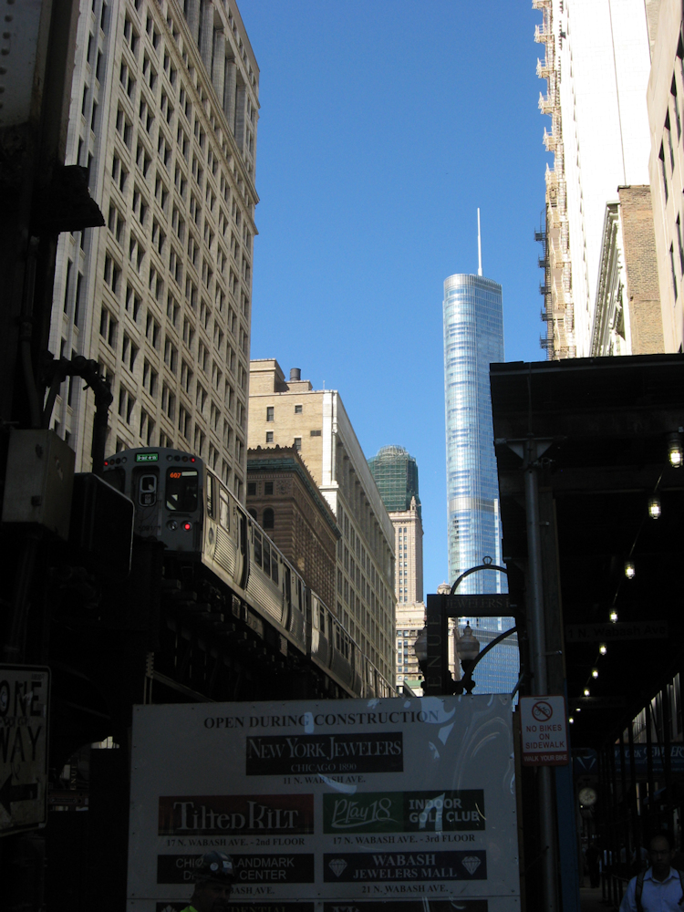
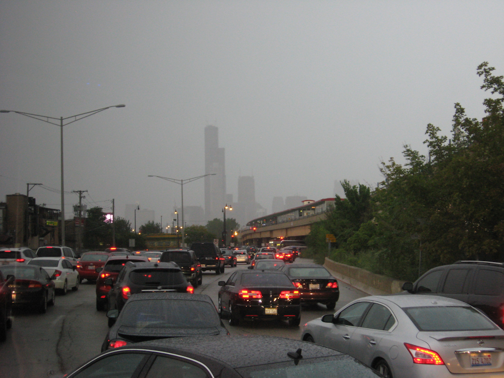 Too many people, trying to head somewhere in a Chicago evening traffic jam under disagreeable weather.
Work
Work is a thing that people do to keep themselves occupied during the day. In return, the people who ask them to do the work give them something – usually money, with which the workers buy stuff and pay taxes, though other benefits (free food, gyms, nice cosy beanbags in discrete corners) are occasionally thrown in to help maintain employee interest. (You can’t eat the beanbag, or use it to buy food, but it provides some variety in sitting space and the Chancellor of the Exchequer hasn’t worked out how to tax it yet either.)
Although there are occasional arguments against the practice, it is usually accepted that pay is linked to the local value of money and the amount of skill and training involved in getting the worker up to speed combined with something about how much the employer is worried that their loyal worker will go to work somewhere else for more money, better job satisfaction or a shorter commute. There is no international index rate for this – or indeed a national index rate, with the result that British junior doctors do years of training to become very highly skilled and then don’t get paid. (In the absence of much fuss about pay cuts before now, one assumes they have never really been paid their value relative to risk that they will realise other things pay more before starting a medical career, but they are now due to not be paid for more hours than they are not being paid for at the moment.)
Commuting
In there is that commute thing. A commute is the act of living at Point A but going to Point B frequently for work and then returning to Point A in the evening. In Britain it was much encouraged by the Metropolitan Railway, which sold the dream of living in the countryside and travelling into London every day to work – rather than living in London, which offered a shorter commute but was a trifle more crowded.
What was in it for the Met? Well, as well as selling you the concept of your dream home (a mock-Tudor semi in an estate of a thousand or so of the things, ten miles out of London and all built from cardboard in about six weeks) the company also aimed to sell you a season ticket for commuting back into London and probably sold the field your house was built in to the property developer. The Second World War stopped property development for some years and opened up vast tracts of real estate in London for nice blocks of flats which didn’t entail commuting on the Met’s crowded trains. Subsequently the bubble was deflated by the Government’s Green Belt policy, so especially obscure corners in Buckinghamshire (not the most developed of the Home Counties) like Verney Junction and Quainton Road remained especially obscure corners of a nice green county.
This is good for the rural landscape. However, it gave people four choices for where to live if they wished to work in London:
- Central London;
- The Met/ Central Line/ Southern Railway suburbs;
- A slightly past-it seaside town (becoming more past-it the more General Franco realised the economic value of being nice to tourists);
- Central Birmingham (non-central Birmingham is slightly nicer but the commute’s longer).
This was fine when the economy spent much of the 1965-85 era in a slump and nobody wanted to live or work in London, but it now has:
- driven up London house prices (until only the rich could afford Central London addresses, it became a status symbol to live in a shabby terraced house off Oxford Street and now the only people who can afford to live there are too rich to actually do so);
- kept the suburbs desirable (no doubt with the Met directors lying in their graves wondering why they didn’t go into renting instead of selling);
- forced the seaside towns to do some regeneration work;
- made lots of people worried that High Speed 2 is in fact merely reinstating the Met’s northern end and running it through to Birmingham for the commuter traffic.
The Government is now talking about more houses. As there is no room for more houses in the centre of London, this presumably means more commuting. As London is the world economy hub these days, this commuting is into London from more outlying places like:
- Ipswich;
- Brighton;
- Southampton;
- Swindon;
- Penzance.
In the process, nice shabby places where nobody particularly wanted to live are now becoming quite pricey. Not all of them are anywhere near London. Journey times from four of the places above are in the order of an hour. (Spot the odd one out.)
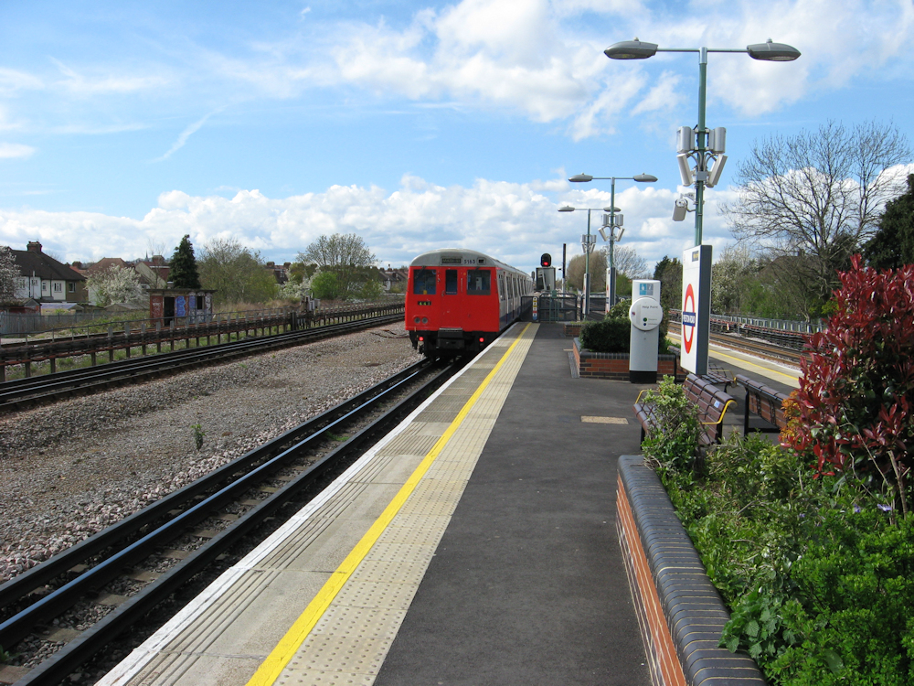 Preston Road station, on the Metropolitan Railway. The wide open suburban landscape and open-air station makes for a much airier way of life than staying in the heart of the capital – in exchange for travelling with the Met.
Why commute?
People have lots of reasons for commuting. It may simply be that two people living together work in different places. One can commute and the other do the cooking, childcare and house maintenance when not commuting or they can both commute the same distance in opposite directions.
They may have moved jobs but not fancy moving house (nice house, kids at school, can’t afford it, friends, cookery club, etc.).
They might have a job which involves working in two or three places and have chosen one to live in. (The Penzance commuters listed above generally find it easier to live in Penzance – nice air, slower pace of life, easier to stop and think, has beaches – but occasionally need to be in London so travel up and down on the Night Riviera Sleeper train. Said Sleeper is promoted for a nice relaxing romantic image, but plenty of the passengers are commuters of some form or another.)
They might prefer living in Chorley Wood and commuting than living in London – Chorley Wood has parks and trees and fields and less pollution and so forth.
They might be looking after family (elderly grannies need someone nearby – the nuclear family still exists in Western culture, just a bit beneath the surface) and want to live near them.
They might like having some distance between themselves and work. It’s nice knowing your boss can’t ask you to pop in for five minutes (which will later read five hours) when you live an hour away. A commute provides time to shrug off stresses of work on the way home, which a 5-minute walk does not. It’s also pleasant to live far enough away to not to have to go past your office to get anywhere. Rail-based commuting also offers time to read the paper and get through a few books (hence why big railway stations have bookshops).
Finally there is the financial side. As city-centre house prices rise, through a combination of demand, general urbanisation and most city centre housing having been blown up by the Luftwaffe but replaced with offices and shopping centres, a lot of people cannot afford to live in city centres. (Except the crummy places with damp, no central heating and single glazing above charity shops, cheap cafes and takeaways, which are fine when straight out of student digs but aren’t family homes.) The solution is to commute; where to commute from is the subject of this formula:
C > s + m
m denotes the monthly mortgage; s is the season ticket cost; C is the cost of living in the city. If the formula is true, it’s worth commuting. So a season ticket from Merthyr Tydfil to Cardiff is £1,076 per annum and a house there will cost an average of £107,000 – somewhere around £4,000 per annum on mortgage payments. Cardiff will set you back £200,000 for the average house, which is more like £8,000 per annum in mortgage payments. Unless you really value the nicer houses, bigger parks, better connectivity, nightlife, coastal position and not being in an ex-industrial town at the bottom of a barren valley, the maths is obvious; you can afford two or three more weeks of holiday a year by commuting.
The Politics of Commuting
Curiously commuting has a reputation for being something that only wealthy people do. This is partly because the Metropolitan Railway made it a “dream home” middle-class sort of thing. When the railways invented commuting (or at least when Parliament passed an Act allowing the Government to subsidise them to do so) it was in the form of cheap “workman fares” which allowed the poorer classes to travel cheaply at peak times (not that access to workman fares was means-tested, so in practice where they were available anyone could use them).
In the 1970s the Labour minister and thinker Anthony Crosland got on a train to Grimsby and noticed that most of the people on the train were, like him, upper middle class or above on the social scale. He argued that this showed that railways are purely for the rich. The Tory Secretary of State for Transport argued something similar to a Select Committee in 2011. The conclusion drawn by both was that rail subsidies went to the better-off. Neither seemed to consider that this was a reflection of the modern level of subsidy. Rail services in the South-East are currently predominantly not subsidised at the point of use (although improvements sometimes are). Crosland’s train was a long-distance service reflecting that only the well-off can usually afford to travel any great distance; the poor and dispossessed tend not to get out of their home town much and walk a great deal. He might have got a different idea if he’d gone to Manchester and looked at the people using the trains there. Instead his Government’s transport subsidies were directed at allowing the poor and dispossessed to fly to New York in four hours on Concorde.
Not subsidising rail affects the balance of the equation above, by jacking up the season ticket costs and making it more economically desirable to live in the crowded city. After house prices in the city have gone up to reflect this, the equation will resettle at a higher level. Looked at from this angle, the quickest way for the Government to cool the London house market is to require (and subsidise) the next South West Trains franchise to halve all its fares, which will substantially re-balance the equation away from urban living; shame the South-Western’s infrastructure couldn’t cope with the resultant traffic increase.
In any event it is arguably highly economically desirable to encourage the better-off to live outside the city centre, away from services, jobs and facilities (which they can afford to travel to) and in the process vacating space for the less well-off to live close to services, jobs and facilities which they can then walk to for free.
The problem is that the better-off largely get there by knowing how to push their weight around and therefore know how to complain that the costs of their commute are unreasonable. A large proportion of London transport infrastructure is in fact purely for commuting and has to be paid for, which at present means unreasonable rail fares. The combination of the reality and the worse perception means that people are looking for opportunities to live in the Big City. Meanwhile the representatives of the poor – most of whom can afford to send their kids to private schools and so are clearly not poor themselves – argue that the minimal remaining commuting subsidy is going to the better-off.
The Economics of Not Subsidising Commuting
The first impact is that people can’t afford to commute, so can add price to the reasons not to commute (mainly time, inconvenience and discomfort – any commute by any form of transport requires an ability to zone out). This encourages them to live near their place of work, near the shops, near the leisure centre, near the pub and near anywhere else they may want to go.
In an optimal world this spreads out employment opportunities to cover a wider swathe of the country, because not everybody can be fitted into a handful of city centres for the job opportunities only available there. Instead, companies locate themselves where land is cheap and their employees move to live nearby. Perhaps the most note-worthy version of this was around railway works – particularly the Great Western Railway’s village adjacent to its Swindon Works. The Works employed people and the GWR provided them with housing – complete with what in the 1830s passed as excellent sanitation – next door to the Works. Also provided were pubs, shops, meeting halls and a set of Public Baths.
 The Railway Village in Swindon faces directly across the road to the former Works. Nowadays the Works hosts light industry, shopping, offices, flats, parking and a museum – a healthy mix of residential opportunities and places to work.
On the plus side, the commute was short and the employer appeared benevolent. On the negative side, your next-door neighbour did the same job as you and your life orientated around a few streets and the tunnel under the mainline to the Works. With extended holiday time and increased leisure budgets, one feels humanity should aspire to slightly more existence than that obtained in a square mile.
Unfortunately we don’t live in an optimal world, so rather than humanity gathering in lots of individual square miles it seems to be dedicated to concentrating itself entirely on one, wholly singular Square Mile. When someone allowed a small administrative town on the north bank of the Thames to evolve into existence sometime more than 2,000 years ago, one feels they might have paid slightly more attention to their planning work if they’d appreciated that they were laying out the ground plan for one of the most expensive square miles in the world.
Because commuting isn’t subsidised (and is inconvenient) people who work in London’s Square Mile like to live as close as possible to it – and therefore their office. With the growth of the financial sector of the British economy, there are a lot of people who are circling the Square Mile looking for a living space that meets their expectations. Some of them are very well-paid indeed. (Some of them presumably aren’t, as there are high-fliers and losers in all industries, but one generally assumes that if a company is investing valuable Square Mile office space in someone then that someone is worth paying well.)
There are various ways that this lack of subsidy can have an impact on the nature of the not-quite-city-centre bits of London. The controversial ones runs broadly as follows. Naturally someone who perceives themselves as a high-flier is unlikely to want to live in a shabby, gang-riddled inner-city estate consisting of grotty terraced houses of indeterminate age. Instead, these houses are occupied by people who can’t afford to live anywhere else and who do jobs like cleaning the office floors, running the sandwich shop, driving vans and repairing cars from a small warehouse on the local industrial estate.
As these terraced houses look untidy, the Council – blessed by Government investment in improving these estates and piles of money from the rates charged on offices – duly spends time and effort tidying them up, resurfacing the roads, cutting the grass in the parks and throwing out the drug dealer who was hiding behind the remaining bush in the park. Buses are encouraged to go that way. Over time, the estates cease to be shabby red-light districts and become places with outrageously hip cafes which look like they might give the punters food poisoning but in fact probably won’t.
Then the rich people who go to the outrageously hip cafes in the evening decide to move to the area because it’s cheap and full of novel watering holes; then it becomes desirable; then the previous locals find they can’t move round the corner because a house that no bank would offer a mortgage for ten years ago is apparently worth three-quarters of a million pounds; then the rents go up and the watering holes go out of business. Sometimes the filthy rich add insult to injury by complaining to the Council about the noise from the rustic clubs and pubs. Meanwhile the industrial estate is flattened and replaced with expensive flats.
The place is now much nicer to live and people who don’t live there feel safe walking through. It is hard to object, because objecting to this “gentrification” is essentially saying that sink estates should remain sink estates because at least they’re cheap to live on – which is a trifle patronising. At the same time, if the office cleaners were renting in this gentrified area they now have to either get a pay rise or pay South Eastern Trains several thousand pounds a year to commute in from somewhere cheaper.
London has found it can accelerate the modernisation process by buying an area a new fleet of trains, doubling the service and putting it on the Tube map. Not many people need to get intrigued by this “new” railway to flood the trains and put an enormous strain on the resources of an area.
 Light industry at Star Lane, with Canary Wharf in the background. Star Lane (Docklands Light Railway) station is one change from Canary Wharf, or about 15 minutes. One one side is a mix of housing and light industry. On the other is light industry and distribution points. Some miles to the west, Transport for London and several developers are looking at a similar tract of land at Old Oak Common and making murmuring noises about flattening the light industry, train maintenance facilities and prison which currently occupy the area and building nice flats there. The problem is that when scarce land gets good transport links the landlord finds they can continue letting to low-margin industry or sell up for several million pounds and go to the Seychelles for a few decades. Meanwhile the people who used to work in the area have no jobs, the postal system has no distribution point and trains go unmaintained.
The Impact of Commuting on the Built Environment
If everyone lives within walking distance of their place of work then they can all walk to work and thereby reduce their impact on the environment, goes the mantra.
It’s a sweet mantra, but a bit disingenuous. Businesses like banking, law and retail management benefit from having a lot of companies from different sectors clustered together. It means that when Company A wishes to sell Company B 40,000 tons of bananas, to be transported by Company C after packaging by Company D, all four companies can get their financial consultants and lawyers together in a room to discuss the value of bananas, when they will be ready and when they will be needed, how much bubble wrap they need and what happens if they get bent in transit without anyone having to travel very far.
What this means in practice is that for this example at least 12 companies want to have their headquarters within 10 minutes’ walk of each other. If one of them is based in Bermuda, two in Manchester, one in Bristol, one in Newcastle and another in Flensburg this is very pretty, broadens employment opportunities and means that the meeting involves video conferencing. The person in Bermuda will be in bed until after lunch, papers have to be agreed in advance of the meeting or can’t be passed around and the video conference, which is three seconds behind at the best of times, will drop out if the satellite goes behind a cloud.
If everyone is in London then the contract can be easily written up in English law (without the person in Flensburg having to find a lawyer to take them through the horrors of English contract law) and everyone can sit down at any convenient time of day.
The problem is that this results in a lot of people wanting to get into office blocks in the centre of London. If they are all to live nearby, then they have to live in a similar fleet of blocks of flats. This leaves little room for things like open space and the tall buildings have an impact on the prevailing climate, particularly at street level. Also, if anyone does ever want to leave this concrete jungle transport facilities are a pain to provide because a railway station or bus stop with a 200-yard catchment on each side will take in twelve or so blocks of flats, or somewhere in the region of 450 homes. 450 people is a comfortable eight-coach trainload. (Twice as many people as that will fit in, just not in any particular comfort.) They will all have to use public transport, because there will be hardly any room for most of them to park cars.
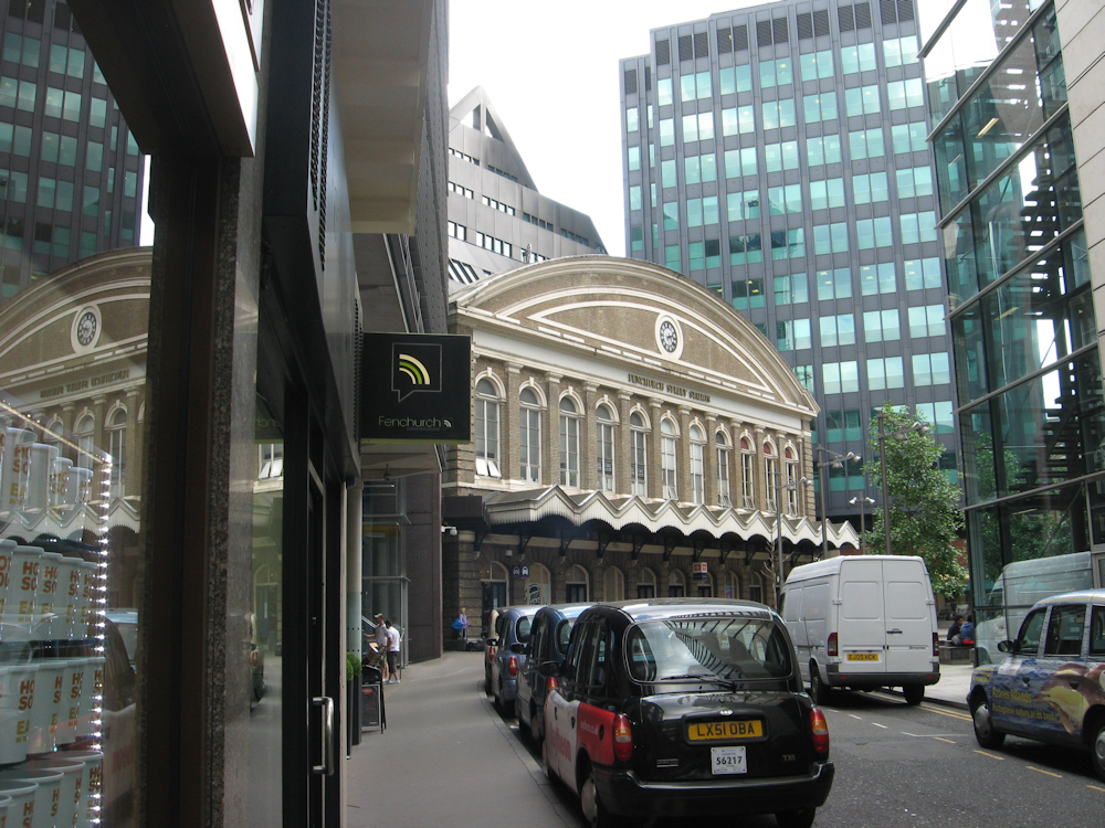 Fenchurch Street station, deep in the Square Mile and surrounded by office blocks. The grey pointy Thing that looks like a Doctor Who monster squatting on the station is in fact a angular office block built over the station. This does nothing for creating a feeling of air and spaciousness on the already small station concourse, which feeds four platforms for the principal route from London along the Thames to Tilbury and Southend.
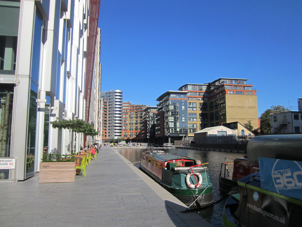 Paddington Basin, at the southern end of the Grand Junction Canal. It’s all very clean and straight off the artist’s page, but also a trifle claustrophobic and lacking in real greenery (even if the canal does offset this a bit). Fancy cafes and expensive estate agents occupy the ground floors.
If we spread them all out a bit, we can have green space, houses with gardens, decent-sized shops (not wedged into the basement) and a reduced impact on the environment. A few bushes in the gardens provide homes for birds and insects; flowers provide food for insects; everyone has room to relax; water can drain into earth rather than fresh-water drains that fill up and flood; the wind doesn’t blow around houses like it blows round tower blocks; schools can be in the open air rather than overlooked by more tower blocks or, indeed, inside a tower block with no sports field.
Transport then gets more manageable loads of people from each individual stop, which make it less of a mass-movement logistics exercise to provide and more of an intelligent planning operation. It does of course need planning intelligently. When people are spread out, things like leisure centres, cinemas, larger shops, secondary schools and bigger parks are likely to be scattered around the outer parts of town – not all convenient to people in one location and not all neatly arranged on the main road into town. Thus transport also needs to allow people to get from point to point around the outer parts of town.
Transport in an Expansive Urban Environment
A visitor to Cardiff will find that the east side of the city is divided into three parts. The Trowbridge/ St Mellons area has a railway but no railway station; public transport consists of two wending bus routes into the city, neither of which takes a route convenient for the local secondary school. (They also try to avoid the leisure centre; the one which does the east end of Trowbridge stays about a mile away at the bottom of a hill, while the other doesn’t actually go past the leisure centre but gets a couple of road junctions away.) The nearby business estate is not best served for buses; one or two of the nicer housing estates aren’t very convenient for them either. Cycling into town is trickier than it really should be – or could be, if the council lashed out a few thousand pounds on a cyclepath around the bottom of the hill.
The middle area, Rumney/ Llanrumney, has the secondary schools and the leisure centre. It is awkwardly positioned for the fast road into Cardiff city centre. There is no local supermarket and cycling into town involves navigating the hill.
The more northern area, Llanedeyrn/ Pentwyn, is placed between the M4 and the fast road into Cardiff – not that access to the motorway is very good. A shopping estate, positioned for easy access to the motorway and what passes as Cardiff’s ring road, is accessed from Pentwyn by means of a series of suburban roads learnt by following the signs put up to stop bus drivers around the estate getting lost. The fast road cuts it off from Llanrumney, which is only accessible by a footbridge. There is no connecting bus service. There is not really a logical route from here into the city centre by bicycle, nor one from here to St Mellons. The popular driving route between the two involves three country lanes and an illegal U-turn at a carefully re-designed junction.
St Mellons is a largely 1970s and later estate, so is completely lacking in small shop facilities (and secondary schools, since they’d already been built elsewhere). Food-buying facilities amount to one, not very large and under-invested-in, branch of Tesco. The large supermarket facilities are in Llanedeyrn (inaccessible by direct public transport) or equally distant from the main road used by the buses, on opposite sides of the same stretch of crowded and polluted highway, three miles into Cardiff. Car ownership begins to verge on compulsory, which is unfortunate for a mixed estate with a high proportion of various forms of social housing. A key rule for attempting modal shift from cars, which the council occasionally claims to be doing, is that not owning a car should not make life indisputably more difficult than owning one.
The three areas really need to duplicate facilities and might as well be separated by four-miles green belts.
In essence, Cardiff is an excellent place to go to see how not to do major urban transport.
 Llanrumney High School, now demolished after it won the award for being Worst School in Wales on the revival of Welsh school league tables. It appears the Education Secretary’s education did not even reach Llanrumney’s standards and failed to drum into him that removing the worst result from a table does not mean that there is no longer a worst result. By the following year it was only fourth worst, but closed anyway. A subject for a different article perhaps. It served the whole East Cardiff area described above, though primarily drew from Llanrumney and St Mellons. Llanrumney pupils could walk, as the school was well located for them about halfway up the estate, albeit on to one side and at the bottom of a hill. St Mellons pupils had the option of a bus or being ferried in a parental car. The school provided bike racks, but no pupil or teacher ever dared to leave a bike lying around – nailed down or not. The school bus appears to be a simple way of resolving poor transport between parts of town by laying on a service to ferry school children around in dedicated vehicles. It has the immense downside that children reliant on the bus, whether because they have no other transport or their parents (singular or plural) are working after school finishes, cannot attend after-school clubs or do school trips without either spending an hour each evening walking home or going through the rather embarrassing process of begging a lift from a friend with car access. This situation results in the potential that an intelligent pupil living in St Mellons and schooling at Llanrumney (for locals now sniggering – they did exist) could be prevented from studying separate Science GCSEs because of the need to do after-school sessions. Linking up areas with frequent formal affordable bus services, whether replacing or augmenting the school bus, would connect communities and increase access to school facilities.
One should, however, be fair to Cardiff. It does still have a suburban rail network around the north and west of the city (the east side was built while railways were unfashionable; one or two could have been fitted in very easily). Across the Severn is Bristol, European Green Capital for 2015.
Bristol has some cyclepaths, largely where someone was obliging enough to close a suburban railway. Mass transport is limited to the Severn Beach branch, which manages to present an image that will only reduce house prices through otherwise desirable areas. Minimal improvements to roads and an awkward city-centre layout means that Green Capital status is more courtesy of nobody being able to emit noxious gases because they can’t get anywhere.
This means that house prices in the Clifton area go up both because Clifton is a nice sort of area (with bridges and one of the handful of suburban stations) and because drivers into the centre of Bristol can spend less time in a traffic jam on the main road into Bristol than would be the case from Henbury. (In fact Clifton is at the outer end of walking distance from the city centre and buses aim to bomb down the main road every five minutes, so is generally a good place to be for avoiding having to drive at all.)
Now with a decent off-road transport system for the same mid-density housing, we could offer a combination of quieter and safer roads (with cleaner air), reduce the disproportionate need to be towards the inner end of the traffic jam and aim to link up areas between major roads. If people can “live and breathe” properly in Bristol then it will become a better place to be based for major business – especially when it’s only 100 minutes from the centre of London. To a certain extent this is being targeted with re-opening of lines to the suburbs of Henbury and Portishead, though both have been on the cards for years and nothing very much has happened (except King Coal paid for the lines in question to be upgraded for coal trains – this is now a dead funding stream). Wider implementation of suburban transport would be useful.
Mass transport does not necessarily have to link everything, but if it can remove the bulk of the obvious flows it will help a great deal. First, households which keep one car for the commute and one for other use can get rid of the commute car; second, eliminating the major in/ out of town and home/ shop/ major leisure destination car flows releases road space for less intensive traffic routes to flow more smoothly; third, quieter roads mean they can be used for children to play; fourth, councils can save money on cycle projects because the roads are more pleasant to cycle on, linking up some less common flows without needing cars or mass transport; fifth, a spacious town with green space, gardens and open roads is kinder to the environment and nicer to live in than a clumped-up concrete affair. But to encourage mass transport, it is necessary to build communities with it in mind and then subsidise it – essentially, to keep following the model of the Metropolitan Railway with discounted fares.
 Cathays station in Cardiff, on the Taff Vale line that brings trains from Merthyr, Aberdare, Treherbert and Pontypool into the centre of Cardiff. The station was built by the Welsh sector of Provincial Services in the mid-1980s. Besides providing rail access to this largely residential area of Cardiff, it also provides a valuable transport link to Cardiff University, which is located around the station (the Students’ Union building is the large brick affair built around the tracks beyond the station). As a result students from Penarth, Barry and the Valleys can attend university on the train without being reliant on procuring a car, which is likely to be beyond their family’s means, or by moving into halls, which for the distances involved is likely to be overkill and also unaffordable in any case. The railway also provides cheap and cheerful transport from the Valleys into Cardiff, allowing people resident in the Valleys to enjoy the higher wages prevalent in Cardiff and consequently greater spending power at home, and attempts to encourage the residents of Cardiff to take the train into the Valleys – which are a trifle more attractive than the slag heaps, winding pit heads and bleak rivers so easily called to mind by the concept of the Rhondda.
 Penryn station, on the railway known as the Falmouth branch and advertised as the Maritime Line but which might be more appropriately called the Falmouth Metro. A half-hourly service – terrible by London standards and incredibly good for Cornwall – connects Falmouth, Penryn and Truro. The train in the foreground (since lengthened to 2 cars) is loading a bicycle before heading to Falmouth; that in the background has a clear signal to depart for Truro. The adjacent wasteland has now become student accommodation, as though aiming to highlight the benefits of convenience for a railway station. The service carries locals tripping between urban areas, commuters to Truro, schoolchildren heading to Penryn and Truro (what the prevalence of Penryn-bound children on Falmouth stations says about Falmouth schools is a matter for the local authority to settle), students for the Penryn combined universities campus (although these are often distracted by the subsidised bus operation that goes onto the campus), various tourist and leisure markets and people from along the branch heading for Truro for onward connections on the mainline. This combination of flows highlights the need for a flexible approach to transport offerings – a local service should bear in mind that when the guard approaches two friends chatting on a train to Truro the fact that the first one has a ticket to Bodmin does not rule out the possibility that the second one wants a ticket to London. Being able to meet both needs is something the passengers will take for granted and only notice if some clever sort farms out the Falmouth branch separately to provide an entirely self-contained operation with no through tickets on the basis that this “better meets local transport needs”. It does not.
 If through ticketing cannot be offered, at least a convenient interchange can be offered where two attractive transport facilities come side by side. Penryn has bus stops on the station road. Cardiff had a bus station sat on the open space outside its main railway station. It was not a particularly scenic bus station, but it was in the open air rather than buried beneath something and it was easy to find when arriving from further afield (or, indeed, Merthyr) on the train. The council owns Cardiff Bus, so can be reasonably expected to make sensible decisions that benefit the bus operation. As a result the bus station has been closed and sold to the BBC, who for some reason want late-night revellers looking for late-night trains after events (of which there are a few in Cardiff, and with the main stadium being convenient for the station and so forth) to be wandering around outside their building looking for toilets and places to leave the remains of their picnics. In due course, once designs have been agreed, a new bus station is to be built more to the left of this view with an office block on top of it. As buses will then take a nice back route in and out of the hidden bus station, visitors to Cardiff may come to the impression that they do not serve the rail station at all. Enclosed bus stations are a constant scourge on bus users inflicted by designers and planners who either consider buses to be unfashionable (which is fair, they are), likely to use facilities which are unattractive (which could be remedied by providing attractive facilities) or disinclined to emit anything which might make burying them under several hundred tonnes of concrete undesirable (which also suggests they have never cycled, since they evidently have no idea what comes out of a bus’s exhaust pipe).
Subsidised efficient mass transport
By making it reasonably possible to travel cheaply in from out of town (and get home at all hours), people can be encouraged to show less concern as to exactly where they live relative to city centres. Those who do insist on living in the centre can get out again easily enough without needing space for personal transport. Less room has to be given over in the centre to wasteful parking space (which encourages flooding by not absorbing rainwater, looks unattractive and is unused much of the time). Less valuable inner-urban space has to be given over to road surfaces as well, allowing broader pavements and simpler layouts at key junctions.
There can then be less concern that having an attractive inner-city area and pleasing housing estates around it will drive out the poor. An all-over socially attractive cityscape will tend to favour the better-off living out of town anyway because out of town has bigger houses, green space and easier access to the countryside. However, where the less well-off do find themselves living in more out-of-town estates they will be able to afford to travel back in; while this occupies valuable time that they then can’t spend earning money, it isn’t as great an evil as when they get priced out of a rising city-centre housing market and can’t afford to work any more.
(The concept of the less well-off occupying valuable time commuting is not intended as a suggestion that a cleaner working 8 hours at £7 per hour and commuting 2 hours per day could live closer to work and then do 10 hours instead. More it is a reflection that a single-parent cleaner who drops the children off at school at 08:30 has to be home by 15:00 to pick them up again, and spending 2 hours of this on a bus via everywhere is a substantial cap on earning abilities.)
 Where the Americans do think to subsidise their public transport they do it well. An elevated train rumbles above the streets of Chicago, taking up no land space and allowing thousands of people to be conveyed to their office doors without needing a car. Since all these thousands of people can be brought in and circled around the city centre loop without needing much land for parking or much space for roads, there is no need to provide serious living space in the city centre. They can all live out in the miles of urban sprawl – either a few hundred yards out in the US equivalent of town houses or several miles out in genuine US suburbs – and commute.
 The dream – bright September sunshine burns out the tarmac road in the leafy small town of Crystal Lake, 45 miles from Chicago. An intensive commuter and hourly daytime service connects it to Chicago, using “bi-level” (double-deck) cars powered by locomotives. Journeys take 1 hour 20 minutes or so, the cars are being refurbished and are reasonably comfortable and the single fare is $8.25 (just under £6). The lake itself has been surrounded by houses.
Money
Subsidies are of course money; money has to come from somewhere. A local authority subsidising its local transport offering probably has to get this out of council tax and business rates, which means cheaper transport but a higher cost of living.
This is not necessarily a bad thing. Everyone benefits from subsidised, well-used public transport: those in the town centre can cross the road safely (and breathe); those from well out of town beyond bus routes and away from railways get smoother journeys into town and less competition for parking spaces; people living by main roads get less noise; there are fewer traffic accidents and therefore fewer days lost to injuries; there is less strain on the local hospital as a result; the community is less insular and the authorities have an incentive to weed out rough areas to protect their investment in the public transport that goes through them.
There is also the element that lightly-used public transport needs something to make it more attractive and a substantial fares cut (coupled, alas, with additional expenditure on railway stations and bus stops, facelifts for vehicles, training to encourage staff to be welcoming, a timetable upgrade with better journey times and so forth) goes a long way to get people interested. Having got people sufficiently interested, loadings can be persuaded to rise until the cost per passenger is relatively low and passengers find that despite the low fares they are meeting most of the cost of the service. What subsidy remains is justifiable because a wide sector of society is using the transport offering and the low fares make it accessible to those on lower incomes.
A good example of this is Bristol’s Severn Beach branch. Much as Bristol’s mass public transport offering is otherwise terrible, the Severn Beach branch reached the stage a few years ago where it would be self-funding if the average passenger paid 50p more per journey. The morning peak return fare from Severn Beach to Bristol Temple Meads is £3 for a 35-45 minute journey.
On a less remunerative option, the South Welsh Valley Lines underwent a bit of a resurgence under local management in the 1980s. Improving train timetables combined with aggressive freshly-deregulated buses to eventually precipitate a fares war. Pontypridd to Cardiff and return sold for 90p. Bus and train earned more money in the heat of a price war than they made at usual prices (more around £1.30 in those days). If this was modal transfer from car, it was cutting car journeys. If it was new travel, it was encouraging people to get out more rather than rotting at home when previously they couldn’t afford to go anywhere. The reduced fares, while on this occasion for competitive benefit, did not necessarily mean higher subsidy. One could argue that cutting South-Eastern’s Anytime fares would encourage more people to use the train off-peak in the belief that it was generally cheaper, even if the Off-Peak fare itself remained the same.
Appearance
Use of public transport is a relatively easy step compared to the task of buying and maintaining an appropriate car. The public transport provider is expected to procure its own appropriate vehicles and maintain them, although there is occasionally temptation to query whether public transport providers are actually that good at procuring appropriate vehicles. Currently the intercity/ interurban direct rail service between the reasonably sizeable cities of Lancaster and Leeds, via Skipton and Keighley (and Clapham), consists of five trains each way per day provided by a train based on a 1980s bus, built by the company that would otherwise have been busy building the bus. Passengers tempted by the 2-hour 0-change journey opportunity advertised on this route (the competition is more in the order of 2½ hours, usually with one change) are advised to bear the rolling stock in mind – although the train will be quieter and the scenery is better than on the route via Manchester. The precise merits of the new trains for the Great Western and East Coast Mainlines are being much debated too, as are the trains for Thameslink that will simultaneously handle two-hour journeys from Bedford to the Brighton seafront and commuters from Luton to London Bridge, but as none of these have yet seen fare-paying passengers comment will be refrained from.
But before we get to the small matter of how nice the vehicles look and the quality of their interiors, there is the question of whether the shop front would persuade an idle traveller to use the local public transport offering. If your first sighting of Redland station is the below, it might discourage usage. There were not many people about later in the week an hour or so later in the evening anyway.
 Redland station, north of central Bristol in the middle of a moderately affluent-looking area and next to a park (hence the black to the right). It looks a bit haunted. First impressions count. Not to say that news reports a few years ago about the theft of the station’s Help Point unit don’t matter as well.
 Hanborough station. Admittedly earlier on a more pleasant evening and in rural Oxfordshire rather than central Bristol, but still a case of it not being that difficult to create a pleasing environment.
Neither of these options is as unprepossessing as the bus option, which is a coldly-lit shelter (if a shelter is provided and if the light still works) next to a road – either busy, in which case it’s unpleasant, or quiet, in which case it’s ominous. In certain areas bus shelters are also patronised by people with little intention of using the bus, and with whom sharing the shelter may not be a personal priority. Users of late-night buses will get the general idea. Non-bus-users who support making everyone use buses will not.
The omnibus has, over the years, managed to procure a reputation for being a cheap and disagreeable form of transport used as a last resort. The 1960s saw rail closures opposed on the basis that replacement buses would not be used by the ex-rail-users. (Some bus companies agreed. Other bus companies opposed the rail closures, or at least were unable to say they could cope with them, on the basis that they couldn’t handle the extra custom – Redditch is one station that survived as a result.)
Once the stations have been spruced up there is then the small matter of the vehicles providing the service. The modern bus is generally a smart and tidy affair:
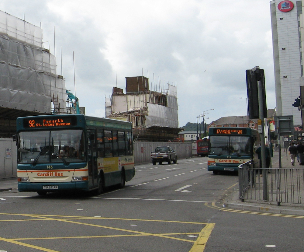 Cardiff Bus, 8 years ago. In the background is the ruins of the main building of the bus station, which was a rather handsome example of mid-century brick Art Deco.
Cardiff Bus has the advantage that buses have a relatively short shelf life – generally about ten years at the outside. The big concerns are handled with a brush, polish and cheerful colours. Cardiff’s late ’90s livery seen above has now been replaced with one featuring an orange face, rising in a big circular sweep into a green bodyside. It’s a striking livery.
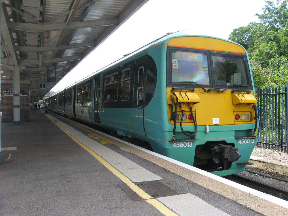
Train operators, by contrast, have the problem that trains tend to push on for something more in the direction of 40 years (or 50, if people forget about them for long enough). This means dated styling stays in use, occasionally with an attempt to drown it beneath new paint, and obsolete features continue dominating journeys. Much as none of the passengers on the class 456 fleet consciously pay them the slightest attention, the units’ Medusa-esque looks must reflect onto customer opinions of them somehow – and also turn out to reflect interior quality:
When Transport for London acquired the Class 378s some 25 years after the 456s were built, it was not going to take much effort to create a product which suggested a higher-quality offering – sealed bodyshells, cleaner lines and a snazzier face going a long way, even before the brighter paint job:
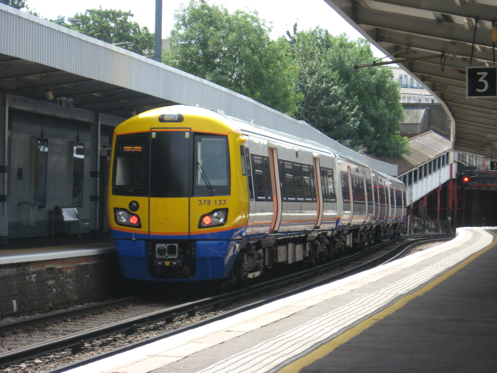
This gives TfL something they can put on the fronts of posters and timetables, whereas Southern’s inner-suburban trains are the sorts of things one prefers to hide from the customers until it is absolutely necessary to reveal them.
Back in the 1980s Valley Lines used to feature its friendly-looking, if rather ancient, diesel multiple unit fleet on timetables and away-day posters. The prototype for their replacements has not come down the years well and when met in 2012 was carrying its original 28-year-old coat of paint after a life mostly spent parked outside. One can still get a sense of the frustration felt by the advertising manager, who apparently (according to the Cardiff Canton depot manager of the time) wanted to know how the hell he was supposed to advertise the poor thing:

Trams just manage to be fairly consistently attractive. Tram designers obviously work harder.
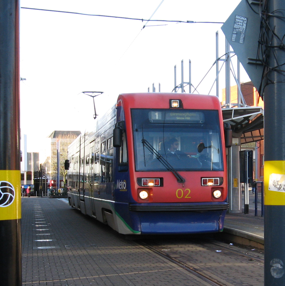 This particular fleet of trams, on the Midland Metro tramline between Wolverhampton and Birmingham, spent most of their life with one or two sets out for component recovery – 02 was the oldest operating set by the time this picture was taken at the end of 2007 – and have now been withdrawn. Part of the problem was the fleet had some slack for route extensions which didn’t happen until recently. The replacements are also a trifle bigger.
The Driverless Electric Car Alternative
This is not an alternative.
The concept of the driverless electric car is essentially that the car driver – whose function nowadays is to be told what to do by an automated female voice, consider obeying traffic lights and periodically contribute to evolution by eliminating lesser life forms (hedgehogs, badgers, users of less crashworthy road vehicles) – will be laid off and replaced by a computer in the car which does all of these things for the driver. The car will then be fitted with a battery and powered by electricity derived from a charging point of some description. When the motorist gets to their destination, they can leave their car to go off and find a charging point until they get out their smartphone, find the car app and summon the car back.
This is a very sweet idea largely conjured up by vested interests with no particular interest in reality.
The standard objection is that if a driverless car (or a car where the driver is leaving the car to fend for itself in the reasonable belief that it is equipped to do so) will leave questions of liability in the event of an accident. Happily the Scottish authorities have been clarifying road vehicle driver liability to prosecution lately (see news article), so we need have no further concerns on that score.
There are however various other points of note. Firstly, a car is a less energy-efficient mode of transport than a train, bus or bike. It has more weight and more front-end air resistance per user for an average load. It is never going to beat a steel-wheel-on-steel-rail train or tram for minimising friction between wheel and right-of-way. This does not change whether the car is powered by petrol, diesel, gas or electricity. A country relying on cars needs more fields to be given over to solar panels than one using public transport. It is a regrettable fact of physics, and wholly unchangeable.
This friction on the tarmac is reflected in the increased noise of a car against a train and the continuous howl of a motorway audible from a mile or two away.
Also against driverless electric cars is that congestion is caused by the number of cars on the road. A traffic jam delaying movement for hours will not cease to be a traffic jam simply because all the cars in it are powered by electricity. It will merely be possible for people walking beside the traffic jam to breathe without being overcome by the petroleum fumes. This is a benefit, but on the sort of level of the victims of the French Revolution being fortunate that the organisers of the Terror had brought guillotines rather than an old axe from the garden shed. It will not remedy in the slightest the massive economic expense of people spending valuable time in traffic jams when they could be at home with their families or in the office working.
Aside from congestion, driverless electric vehicles will still be occupying road space, both for parking and movement, clogging up space which could be used for walking, blocking up the free flow of public transport and discouraging cycling. A side road in a suburban area without parked cars and with little traffic is a better makeshift play area than a side road consisting of nose to tail parked cars being used as a rat-run (or simply as the main access to a large estate). If children are not getting enough fresh air and exercise, having car-polluted towns where they risk being knocked down while running to the park is not a way of solving the problem. Driving them to the park doesn’t solve it either.
The concept that the car will be able to leave its driver behind and proceed to a parking space is one that floats around occasionally, but will also serve to increase congestion by making more cars use the roads – some of them needlessly burning valuable energy hunting for somewhere to park up.
Making a car driverless will not necessarily allow a driver to work in it. A car is a small and awkward space. The motion of road vehicles – and cars in particular – is not necessarily conducive to reading a map in comfort, let alone reading the newspaper – regardless of recent adverts promoting in-car entertainment for small children. There may be some benefits in helping drivers in traffic jams ignore the fact that they are in a traffic jam.
There is also the simple matter that we already have electric trains, electric trams and electric trolley-buses. Most of these require relatively well-understood degrees of expenditure (providing homework is done and feature creep doesn’t slip in), are based on existing technology and can be supplied very easily. The electric car might well be a wonderful disruptive influence, and one hesitates to be a Luddite, but in many ways it is simply not worth the expense of supporting its roll-out when take-up and practical value are either unclear or non-existent. The concept may have some benefits for those living in particularly rural areas where provision of public transport is unviable.
 Marlborough Town Centre will not be enhanced by making all these cars run on electricity. There will still be traffic jams on the main roads in; it will still be impossible to find anywhere to park; the main road will still consist of a mass of unattractive tarmac rather than being offset with some paving and gardens; crossing the road or cycling along it will be a challenge. There will merely be less local CO2 and less noise. Re-opening the railway between the mainlines at Swindon and Savernake would, by contrast, allow some visitors to come directly by train, encourage park and ride for many others and take strain off the main road from East Mid-Wiltshire to Swindon, which passes through Marlborough.
The Other Way
Here are some pretty pictures:
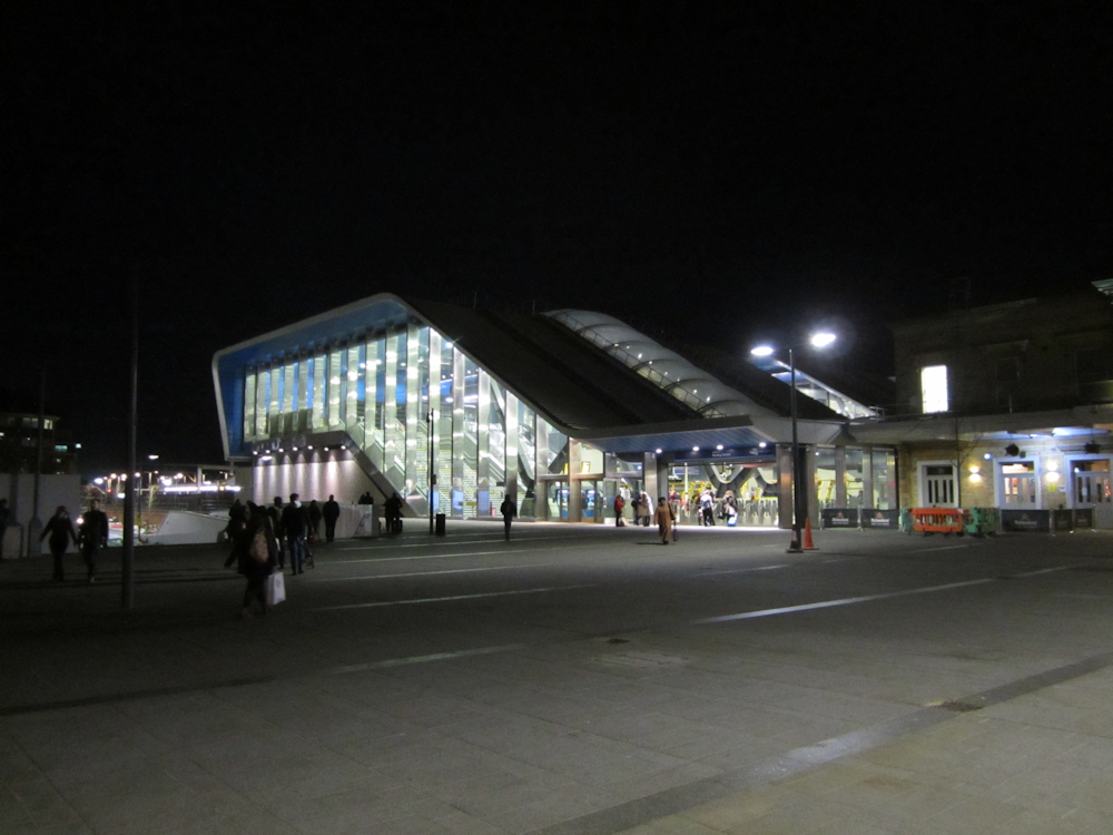 The new Reading station, showing how to design a big and inviting modern station.
 Inside, escalators and stairways are wide, open, well lit and clean. The blue is soothing. There is sufficient spare capacity in the design to prevent it feeling crowded.
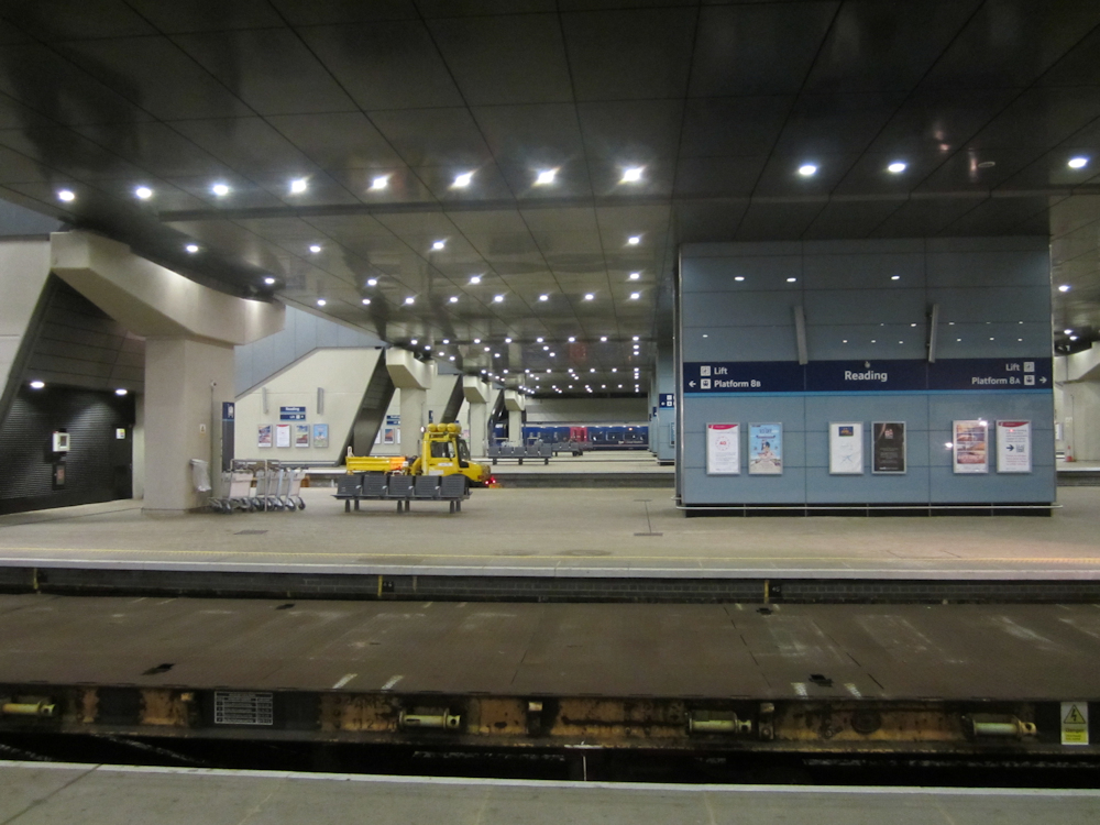 The platforms. Admittedly on a Sunday evening during a partial engineering possession, but pleasantly bright and airy beneath the huge footbridge. Spotlighting creates an air slightly reminiscent of the night sky. The effect is rather good and waits to be transferred elsewhere.
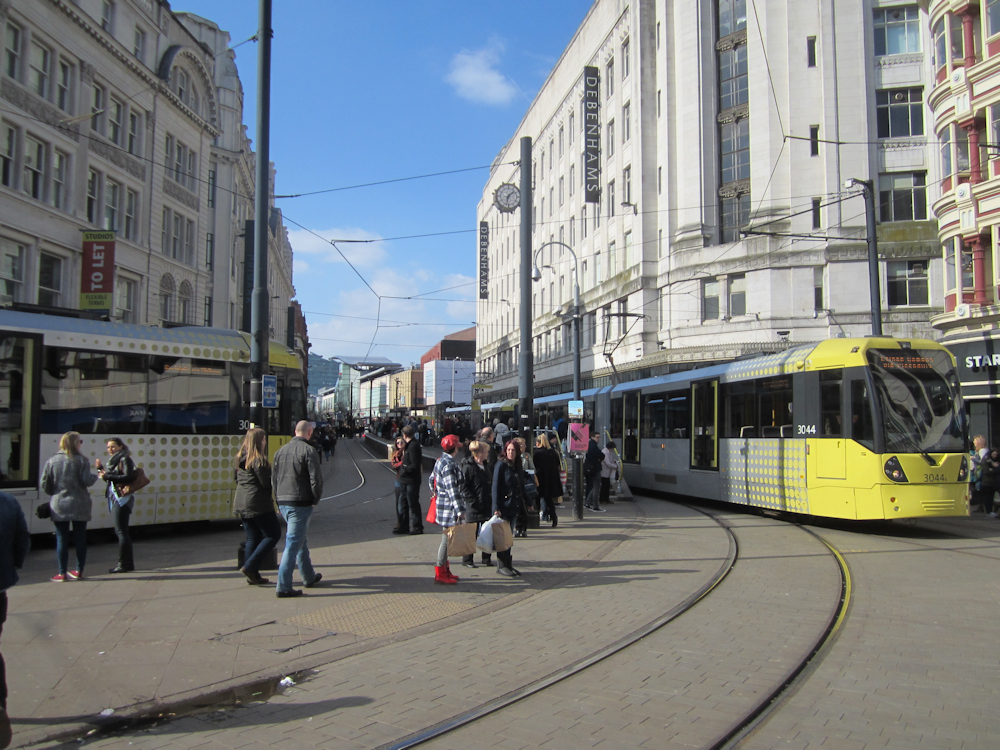 Manchester’s main shopping district, with its distinctive new yellow trams.
 Trondheim – the world’s most northerly tram system runs through the city’s southern suburbs up a steep hillside.
 Gothenburg – the Swedish city centre is seen on a warm June day with the central station in the right background, trams in the middle and canal (now decorative, though could be used for waterbuses) in the foreground. Behind the trams are an array of hotels.
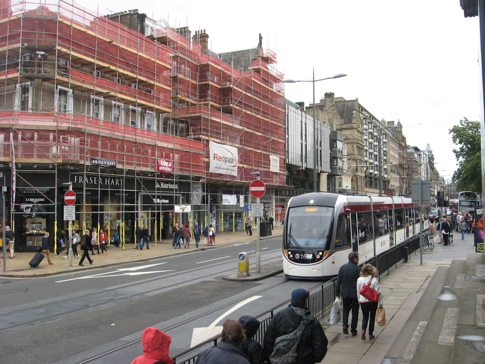 An Edinburgh tram hurries through a road junction on Princes Street. The project misjudged its budget and is accordingly viewed as a bit of a failure, but the trams are packed and the Council is unable to resist planning extensions.
 It helps that Edinburgh has a lot of disused suburban railways. This former trunk route links the Forth-side quays at Newhaven with Waverley station via a couple of miles of intact trackbed, a Tesco superstore and a long-disused tunnel that finishes up on Waverley’s platform 20. It makes a pretty cycle route, but would be better with the cycles on road and the trams bounding down here. A junction has been laid in for taking trams onto one of Edinburgh’s ex-railway cycle routes, but with budgetary problems it is yet to be taken up.
 Rural rail on a shoestring 1: The Plymouth suburban line towards its outermost extreme at Sandways crossing, high above the Tamar Valley above Calstock and a mile or so from the line’s little Metro terminus at Gunnislake station.
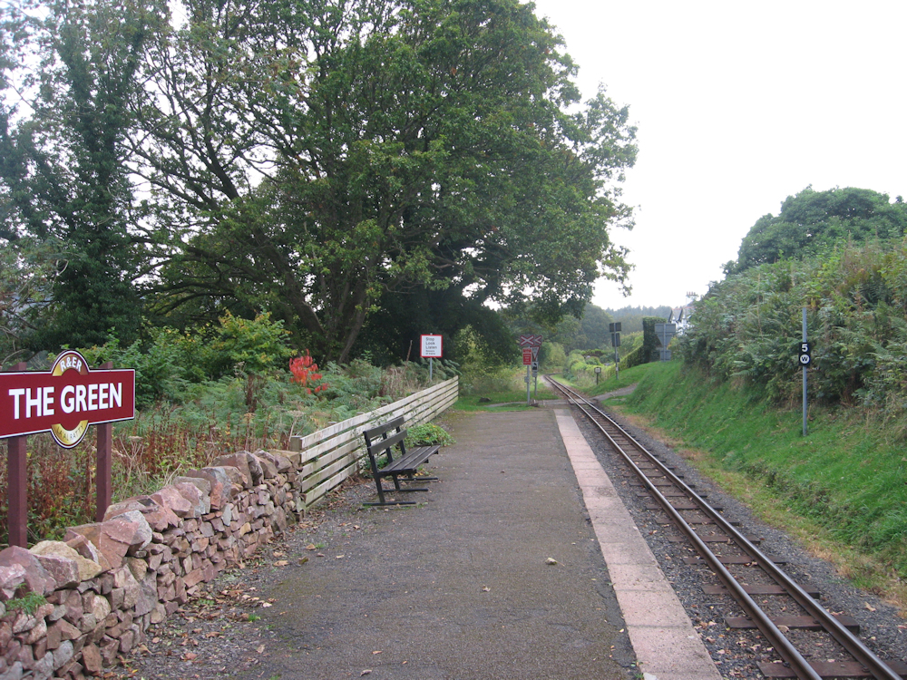 Rural rail on a shoestring 2: The Green station, on La’al Ratty – the Ravenglass & Eskdale Railway. Now run more for tourists, it formerly provided a real transport function including the carriage of stone traffic. It is not much to say that journey times are better than a fit fast-moving risk-taking cyclist, but on the other hand said cyclist did a good job at keeping up with the school bus tailback so perhaps not much of an insult. Ratty trains are mostly steam-hauled and feature a mix of roofless, open-sided and enclosed coaches. There are also some “Maxi” vehicles showing what can be done with the loading gauge around 15-inch-gauge track, based on vehicle weight and centre of gravity. These are quite comfortable and suggest that a decent rural commuter operation would not be unachievable, over reasonably short distances, using miniature-gauge trains.
 At the other end of the scale – modern London metro. An S7 set on the District Line rumbles into Richmond station as a North London Line Class 378 waits to leave. Promoting the North London service, improving the rolling stock and to a certain extent simply showing an interest in its continued existence has resulted in a need for a capacity increase from 3-car trains mostly seated to 5-car trains mostly not. These are National Rail 5-car trains so take up about the same platform space as the District Line 7-car train. (Underground cars are shorter than National Rail ones.)
 A line-level view of the Chicago “L” – the elevated electrified Metro system running around the centre and out into the suburbs of the American city of Chicago. The concept is interesting, although the train design is a bit American and could do with being made a trifle less austere – not that this seems to entirely discourage riders.
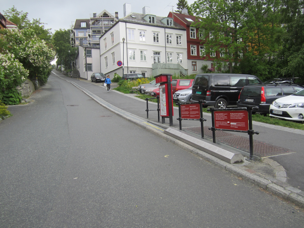 Making cycling up hills easier – if less inclined to help cyclists get fit: the Trondheim bike lift. A useful thing, considering the weight of Trondheim’s hire bikes…
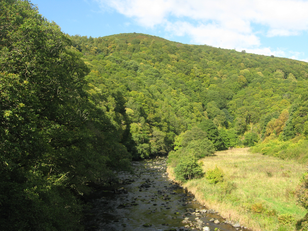 The view from the train – or what would be the view from the train if the line between Penrith and Keswick hadn’t closed in 1972. The railway that hurried onwards from Keswick up the side of Bassenthwaite Lake closed rather earlier and has vanished beneath a dual carriageway. Visitors to the Lakes now clog up Keswick looking for somewhere to park a car instead. Drivers are unable to appreciate the landscape which justified coming as they are too busy watching the road. Meanwhile the transport corridor which could bring the visitors in by the thousand, reduce road noise, cut pollution and save wasting valuable National Park land on parking provides a leisure link for a few visitors and a (rather inadequate, both in length and ride quality) way for cyclists to escape an unnecessarily busy road.
One major problem with current transport policy is that commuter travel gets support but busy routes into popular leisure areas often do not – except in a few parts of Scotland and Wales, where they are necessary to bring anyone in at all. This is odd in many ways, as commuters make up a small proportion of transport users. A policy of encouraging the provision of leisure railways (to places like Alton Towers, where some effort is being made to sort of solve the problem) would somewhat ease the matter of people who can take the train all week still needing a car to go away at weekends – and then using it during the week anyway. A total “no-car” lifestyle is manageable but becomes harder with a family when attractions need to be accessible, not a three-mile walk over muddy fields and puddly paths. So while this article has been predominantly based around the urban environment and the commuter, we finish with a picture of the Welsh Highland Railway – a charity venture allowing trainloads of people to be taken to the heart of Snowdonia without needing to bring cars or widen the roads. The train passes from Beddgelert through the Aberglaslyn Pass into the tunnels towards Porthmadog, the steam dissipates and then all is quiet for the walkers, save for the sheep, the birds and the adjacent road (hidden amongst the trees to deaden the sound, blocking the view in the process). The south end of the railway is convenient for National Rail. The north end is not (although there is a bus option) owing to a combination of 1960s transport planning and the current attitude of the Welsh Government to rail projects.


